IMAGES TAKEN NEAR TO
Llewellyn Street, FERNDALE, CF43 3LF
Introduction
This page details the photographs taken nearby to Llewellyn Street, CF43 3LF by members of the Geograph project.
The Geograph project started in 2005 with the aim of publishing, organising and preserving representative images for every square kilometre of Great Britain, Ireland and the Isle of Man.

There are currently over 7.5m images from over14,400 individuals and you can help contribute to the project by visiting https://www.geograph.org.uk
Image Map
Images are licensed for reuse under creativecommons.org/licenses/by-sa/2.0
Notes
- Clicking on the map will re-center to the selected point.
- The higher the marker number, the further away the image location is from the centre of the postcode.
Image Listing (60 Images Found)
Images are licensed for reuse under creativecommons.org/licenses/by-sa/2.0
Image
Details
Distance
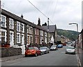
1
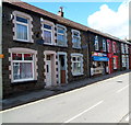
Pontygwaith Newsagents
R & LI Hughes, Newsagents, 76 Llewellyn Street, Pontygwaith.
Image: © Jaggery
Taken: 19 Sep 2012
0.02 miles
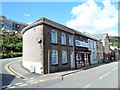
2
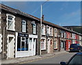
Kieranz Kutz Barbers, Pontygwaith
Viewed across Llewellyn Street.
Image: © Jaggery
Taken: 20 Aug 2013
0.02 miles
3
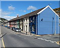
A blue and deep blue corner in Pontygwaith
This is the corner of Llewellyn Street (ahead) and Dolgwilym Street.
Image: © Jaggery
Taken: 19 Sep 2012
0.03 miles
4
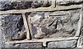
Ordnance Survey Cut Mark
This OS cut mark can be found on No92A Llewellyn Street. It marks a point 152.440m above mean sea level.
Image: © Adrian Dust
Taken: 18 Jun 2017
0.04 miles
5
Madeline Street Pontygwaith
Viewed from near the corner of Baglan Street looking past the former St Mary Magdalene Church. http://www.geograph.org.uk/photo/3591047
Image: © Jaggery
Taken: 8 Aug 2013
0.05 miles
6
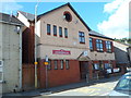
Mostly Pound Shop, Pontygwaith
The shop at 72 Llewellyn Street has two names.
The nameboard shows R F John D.I.Y Fancy Goods. The banner above it shows Mostly £ Shop.
Image: © Jaggery
Taken: 19 Sep 2012
0.06 miles
7
Pontygwaith Non-Political Club, Pontygwaith
On the corner of Dolgwilym Street and Grove House Court.
Image: © Jaggery
Taken: 19 Sep 2012
0.06 miles
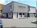
8
Pontygwaith Community Centre
Viewed from an unnamed side road connecting Madeline Street behind the camera with Llewellyn Street ahead.
http://www.geograph.org.uk/photo/3587568 to a view across Llewellyn Street.
Image: © Jaggery
Taken: 8 Aug 2013
0.07 miles
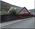
9
Pontygwaith Community Centre, Pontygwaith
Viewed across Llewellyn Road. Pontygwaith Community Centre is open five days a week (Monday to Friday), providing various activities for all ages. Inside the centre is the Community Cafe selling low cost, home-cooked meals. There is a local delivery service for housebound residents.
Image: © Jaggery
Taken: 19 Sep 2012
0.07 miles
10
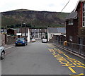
Down School Street, Pontygwaith
School Street descends past Pontygwaith Primary School http://www.geograph.org.uk/photo/3591180 on the right towards Madeline Street.
The bleak hillside was formerly part of an area of quarries and tips.
Image: © Jaggery
Taken: 8 Aug 2013
0.07 miles