IMAGES TAKEN NEAR TO
East Road, FERNDALE, CF43 3BU
Introduction
This page details the photographs taken nearby to East Road, CF43 3BU by members of the Geograph project.
The Geograph project started in 2005 with the aim of publishing, organising and preserving representative images for every square kilometre of Great Britain, Ireland and the Isle of Man.

There are currently over 7.5m images from over14,400 individuals and you can help contribute to the project by visiting https://www.geograph.org.uk
Image Map
Images are licensed for reuse under creativecommons.org/licenses/by-sa/2.0
Notes
- Clicking on the map will re-center to the selected point.
- The higher the marker number, the further away the image location is from the centre of the postcode.
Image Listing (61 Images Found)
Images are licensed for reuse under creativecommons.org/licenses/by-sa/2.0
Image
Details
Distance
1
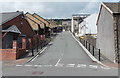
Up Hirwaun Place, Tylorstown
Looking up Hirwaun Place from Edmund Street towards the A4233 East Road.
Tylorstown Band's bandroom http://www.geograph.org.uk/photo/3622796 is on the left corner.
Image: © Jaggery
Taken: 20 Aug 2013
0.02 miles
2
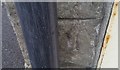
Ordnance Survey Cut Mark
This OS cut mark can be found on No75 East Street. It marks a point 205.484m above mean sea level.
Image: © Adrian Dust
Taken: 24 Jun 2017
0.03 miles
3
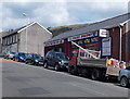
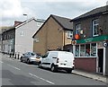
SHL Autos Ltd, Tylorstown
Located at 166 East Road, on the corner of Prospect Place. The business sells car parts (batteries, exhausts, radiators, clutches etc)
Image: © Jaggery
Taken: 8 Aug 2013
0.03 miles
4
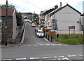
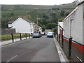
Up Prospect Place, Tylorstown
Prospect Place ascends from East Street towards the A4233 East Road.
Image: © Jaggery
Taken: 20 Aug 2013
0.03 miles
5
Tylorstown Post Office
The post office is in East Road, opposite the Brynbedw Road junction.
Image: © Jaggery
Taken: 8 Aug 2013
0.03 miles
7
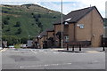
Pendyrus Court, Tylorstown
Viewed across East Road. Pendyrus Court, in Hirwaun Place, contains 12 1-bedroom flats built in 1992. Managed by Rhondda Housing Association, the flats are age exclusive housing. New residents must be at least 50 years old.
Image: © Jaggery
Taken: 8 Aug 2013
0.04 miles
8
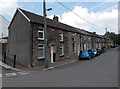
Long row of houses, East Street, Tylorstown
The 80 metre long row extends from the corner of Hirwaun Place on this side to the corner of Prospect Place ahead.
Image: © Jaggery
Taken: 20 Aug 2013
0.04 miles
9

Tylorstown Band bandroom
The bandroom is on the corner of Edmund Street and Hirwaun Place, Tylorstown.
Tylorstown Band dates its origins to 1920, the year of the formation of Tylorstown & District Silver Band.
Image: © Jaggery
Taken: 20 Aug 2013
0.04 miles
