IMAGES TAKEN NEAR TO
Tallis Street, TREORCHY, CF42 6LU
Introduction
This page details the photographs taken nearby to Tallis Street, CF42 6LU by members of the Geograph project.
The Geograph project started in 2005 with the aim of publishing, organising and preserving representative images for every square kilometre of Great Britain, Ireland and the Isle of Man.

There are currently over 7.5m images from over14,400 individuals and you can help contribute to the project by visiting https://www.geograph.org.uk
Image Map
Images are licensed for reuse under creativecommons.org/licenses/by-sa/2.0
Notes
- Clicking on the map will re-center to the selected point.
- The higher the marker number, the further away the image location is from the centre of the postcode.
Image Listing (74 Images Found)
Images are licensed for reuse under creativecommons.org/licenses/by-sa/2.0
Image
Details
Distance
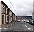
1
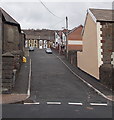
Park Terrace, Cwmparc
Viewed from Park Road looking up Park Terrace towards Tallis Street.
The edge of Park Chapel http://www.geograph.org.uk/photo/4101704 is on the left.
Image: © Jaggery
Taken: 4 Apr 2014
0.01 miles
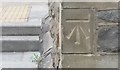
2
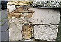
Ordnance Survey Cut Mark
This damaged OS cut mark (arrow missing) can be found on No6 Park Terrace. It marks a point 212.967m above mean sea level.
Image: © Adrian Dust
Taken: 9 Nov 2020
0.01 miles
3
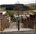
Steps down from Vicarage Terrace, Cwmparc
Steps descend to Tallis Street.
Image: © Jaggery
Taken: 4 Apr 2014
0.02 miles
4
Stanley Court, Cwmparc
The Tallis Street side of Stanley Court flats, on the corner of Park Terrace.
Image: © Jaggery
Taken: 4 Apr 2014
0.02 miles
5
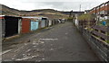
Lockup garages in Cwmparc
In the lane on the west side of Church Street, between Vicarage Terrace and Tallis Street.
Image: © Jaggery
Taken: 4 Apr 2014
0.02 miles
6
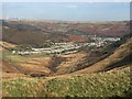
Cwmparc, Treorchy
View from the Bwlch down the Cwm Dâr valley towards Cwmparc. Note the A4061 winding its way down into the valley below.
Image: © Alan Hughes
Taken: 30 Oct 2017
0.03 miles
7
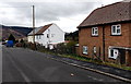
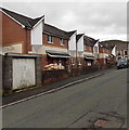
Vicarage Terrace houses, Cwmparc
These houses on the south side of Vicarage Terrace look several decades newer than
the row of houses http://www.geograph.org.uk/photo/4121455 on the north side.
Image: © Jaggery
Taken: 4 Apr 2014
0.03 miles
8
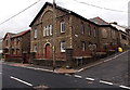
Park Chapel, Cwmparc
Welsh Methodist/Presbyterian chapel on the corner of Park Road and Park Terrace. The inscription in Welsh in a roundel above the triple windows shows that the building was erected in 1873 as Park Calvinistic Methodist Chapel.
Image: © Jaggery
Taken: 4 Apr 2014
0.05 miles
9
Tallis Street, Cwmparc
Looking east across Woodland Terrace.
Image: © Jaggery
Taken: 4 Apr 2014
0.05 miles
10
Ordnance Survey Cut Mark
This OS cut mark can be found on the Park Chapel. It marks a point 204.850m above mean sea level.
Image: © Adrian Dust
Taken: 28 Apr 2017
0.05 miles