IMAGES TAKEN NEAR TO
High Street, TREORCHY, CF42 6AT
Introduction
This page details the photographs taken nearby to High Street, CF42 6AT by members of the Geograph project.
The Geograph project started in 2005 with the aim of publishing, organising and preserving representative images for every square kilometre of Great Britain, Ireland and the Isle of Man.

There are currently over 7.5m images from over14,400 individuals and you can help contribute to the project by visiting https://www.geograph.org.uk
Image Map
Images are licensed for reuse under creativecommons.org/licenses/by-sa/2.0
Notes
- Clicking on the map will re-center to the selected point.
- The higher the marker number, the further away the image location is from the centre of the postcode.
Image Listing (174 Images Found)
Images are licensed for reuse under creativecommons.org/licenses/by-sa/2.0
Image
Details
Distance
2
Ogmore & Garw Valleys direction & distances sign, Station Road, Treorchy
The sign at the northern end of Station Road shows Bridgend 15 (miles), Cymer (Afan) 10, Port Talbot 19. Nearer locations are the hospital Ysbyty George Thomas and Cwmparc.
Image: © Jaggery
Taken: 6 Mar 2020
0.04 miles
3
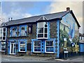
Former HSBC branch, Treorchy
In March 2020, Domino's Pizza is at 11 High Street on the corner of Chapel Street.
HSBC Treorchy was here in January 2012. https://www.geograph.org.uk/photo/2790752
Image: © Jaggery
Taken: 6 Mar 2020
0.04 miles
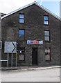
4
Former public toilets, Station Road, Treorchy
In March 2020, a notice on the door on the right states that these toilets are now closed - please use the new facilities attached to the library.
Image: © Jaggery
Taken: 6 Mar 2020
0.04 miles
5
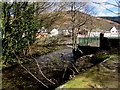
Nant Cwm-parc towards the Rhondda River, Treorchy
The stream Nant Cwm-parc flows towards its confluence with the Rhondda River on the right.
Image: © Jaggery
Taken: 6 Mar 2020
0.04 miles
6
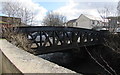
West side of Station Road river bridge, Treorchy
The bridge carries the A4061 Station Road over the Rhondda River.
Image: © Jaggery
Taken: 6 Mar 2020
0.04 miles
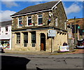
7
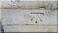
Ordnance Survey Cut Mark
This OS cut mark can be found on the Bank at No11 High Street. It marks a point 161.041m above mean sea level.
Image: © Adrian Dust
Taken: 28 Apr 2017
0.05 miles
8
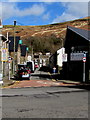
NE along Chapel Street, Treorchy
From High Street along Chapel Street towards New Chapel Street.
Image: © Jaggery
Taken: 6 Mar 2020
0.05 miles
9
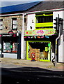
Sweetilicious in Treorchy
Sweet shop at 9 High Street Treorchy viewed in March 2020.
Image: © Jaggery
Taken: 6 Mar 2020
0.05 miles
10
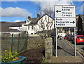
Directions sign alongside Station Road, Treorchy
Facing northbound traffic on the A4061 Station Road. Turn left ahead for the A4061 towards Treherbert and Hirwaun (A465) or right into the A4058 for Porth and Pontypridd.
Image: © Jaggery
Taken: 6 Mar 2020
0.05 miles