IMAGES TAKEN NEAR TO
Halifax Terrace, TREORCHY, CF42 5SU
Introduction
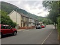
This page details the photographs taken nearby to Halifax Terrace, CF42 5SU by members of the Geograph project.
The Geograph project started in 2005 with the aim of publishing, organising and preserving representative images for every square kilometre of Great Britain, Ireland and the Isle of Man.

There are currently over 7.5m images from over14,400 individuals and you can help contribute to the project by visiting https://www.geograph.org.uk
Image Map
Images are licensed for reuse under creativecommons.org/licenses/by-sa/2.0
Notes
- Clicking on the map will re-center to the selected point.
- The higher the marker number, the further away the image location is from the centre of the postcode.
Image Listing (65 Images Found)
Images are licensed for reuse under creativecommons.org/licenses/by-sa/2.0
Image
Details
Distance
1
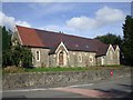
Disused (?) Church in St Albans Terrace, Tynewydd
Image: © John Lord
Taken: 10 Sep 2008
0.03 miles
2
Closed St Alban's church, Tynewydd
The church, at the junction of St Alban's Road, St Alban's Terrace and Blaen-y-cwm Road, was opened in 1891. It closed in 1999.
Image: © Jaggery
Taken: 23 Jan 2012
0.04 miles
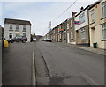
3
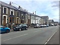
Wyndham Street
Terraced houses on the B4522 from Blaenrhondda to Treherbert.
Image: © Alan Hughes
Taken: 8 Aug 2019
0.05 miles
4
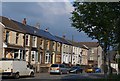
St Albans Terrace
A short terrace of typical Valleys houses.
Image: © Helen
Taken: 19 Jun 2013
0.05 miles
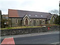
5
Halifax Terrace, Tynewydd
From Wyndham Street, Halifax Terrace ascends towards Upper St Alban's Road.
Image: © Jaggery
Taken: 13 Nov 2017
0.05 miles
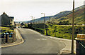
6
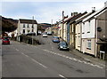
Junction of Halifax Terrace and the B4522, Tynewydd
Halifax Terrace climbs away from the B4522, which is named Wyndham Street
behind the camera and St Alban's Terrace ahead on the left.
Image: © Jaggery
Taken: 13 Nov 2017
0.06 miles
7
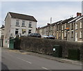
St Alban's Terrace telecoms cabinets, Tynewydd
A Virgin Media cabinet is on the right, next to a BT cabinet. Halifax Terrace houses are behind the stone wall.
Image: © Jaggery
Taken: 13 Nov 2017
0.08 miles
8
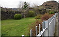
Site of demolished former Blaenrhondda station
Viewed from the edge of the B4522 in Tynewydd. The station was on the route from Treherbert to Swansea via Neath. The station and line were closed in 1968. The nearest railway station is now Treherbert, the terminus of the Rhondda Line from Cardiff Central. Treherbert station is about 1.2km to the southeast.
Image: © Jaggery
Taken: 13 Nov 2017
0.08 miles
9
Blaen y Cwm Road
Terraced houses in Blaen y Cwm Road.
Image: © Alan Hughes
Taken: 8 Aug 2019
0.08 miles
10
Blaenrhondda station site/remains, 1973
View SE, towards Treherbert: ex-GWR (Rhondda & Swansea Bay) Swansea East Dock - Neath - Treherbert line, which between Blaengwnfi and here passed through the mountain by a tunnel nearly two miles long. The station and line were closed 26/2/68.
Image: © Ben Brooksbank
Taken: 29 Sep 1973
0.08 miles