1
Blaenrhondda Social Club
Located on the south side of Chapel Street. The inscription in stone above the blue door shows
FERNHILL & BLAENRHONDDA WORKMENS INSTITUTE AD 1912.
Groups meeting here include the Community Association, keep fit, and darts, snooker, pool and indoor bowls teams.
Image: © Jaggery
Taken: 23 Mar 2011
0.03 miles
2
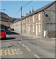
Brook Street houses, Blaenrhondda
A long row of houses on the east side of the street, north of Blaenrhondda Methodist Church. http://www.geograph.org.uk/photo/2344499
Image: © Jaggery
Taken: 23 Mar 2011
0.03 miles
3
Former railway line, Blaenrhondda
This is the route of the former railway line linking Fernhill Colliery at the top of the Rhondda Valley to the main line. Since the colliery closed it has become a popular walk.
Image: © Helen
Taken: 29 Nov 2014
0.05 miles
4
Ordnance Survey Cut Mark
This OS cut mark can be found on the Chapel on Brook Street. It marks a point 211.803m above mean sea level.
Image: © Adrian Dust
Taken: 29 Apr 2017
0.05 miles
5
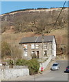
Two semis, Chapel Street, Blaenrhondda
These two houses are the only dwellings on Chapel Street. The rest of the street includes the perimeter fences and walls of Brook Street houses, a small parking area, and a social club. http://www.geograph.org.uk/photo/2344597
Image: © Jaggery
Taken: 23 Mar 2011
0.06 miles
6
Blaenrhondda telephone box and Pen-pych
Image: © Gareth James
Taken: 23 Jun 2012
0.07 miles
7
Public toilets, Blaenrhondda Park
Located on the SE side of Blaenrhondda Park, next to the bridge http://www.geograph.org.uk/photo/2344425 over the Rhondda Fawr river.
In the background are Brook Street houses.
Image: © Jaggery
Taken: 23 Mar 2011
0.08 miles
8
Blaenrhondda Methodist Church sign board
The church http://www.geograph.org.uk/photo/2344499 is on Brook Street.
Image: © Jaggery
Taken: 23 Mar 2011
0.08 miles
9
Blaenrhondda Methodist Church
Located on Brook Street, two doors from the post office. http://www.geograph.org.uk/photo/2344245
Image: © Jaggery
Taken: 23 Mar 2011
0.08 miles
10
Path through Blaenrhondda Park
The path runs along the west bank of the Rhondda Fawr river. The line of trees are next to a fence at the edge of the river.
Image: © Jaggery
Taken: 23 Mar 2011
0.08 miles


