IMAGES TAKEN NEAR TO
Dumfries Street, TREORCHY, CF42 5PY
Introduction
This page details the photographs taken nearby to Dumfries Street, CF42 5PY by members of the Geograph project.
The Geograph project started in 2005 with the aim of publishing, organising and preserving representative images for every square kilometre of Great Britain, Ireland and the Isle of Man.

There are currently over 7.5m images from over14,400 individuals and you can help contribute to the project by visiting https://www.geograph.org.uk
Image Map
Images are licensed for reuse under creativecommons.org/licenses/by-sa/2.0
Notes
- Clicking on the map will re-center to the selected point.
- The higher the marker number, the further away the image location is from the centre of the postcode.
Image Listing (225 Images Found)
Images are licensed for reuse under creativecommons.org/licenses/by-sa/2.0
Image
Details
Distance
1
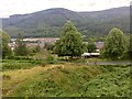
Housing in Treherbert
View of Treherbert from the A4061.
Image: © Alan Hughes
Taken: 8 Aug 2019
0.00 miles
2
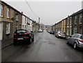
Dumfries Street, Treherbert
From Church Street along Dumfries Street towards Crichton Street.
Image: © Jaggery
Taken: 26 Oct 2017
0.03 miles
3
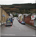
Up Crichton Street, Treherbert
Crichton Street ascends from Bute Street towards Dumfries Street.
Image: © Jaggery
Taken: 9 Nov 2017
0.03 miles
4
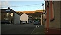
Crichton Street, Treherbert
Looking up Crichton Street from its junction with Dumfries Street.
Image: © Helen
Taken: 23 Nov 2014
0.03 miles
5
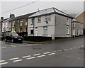
Corner of Church Street and Dumfries Street, Treherbert
Dumfries Street is on the left.
Image: © Jaggery
Taken: 26 Oct 2017
0.03 miles
6
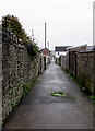
A back lane in Treherbert
From Church Street to Crichton Street between Dumfries Street and Bute Street.
Image: © Jaggery
Taken: 26 Oct 2017
0.04 miles
7
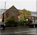
Former Treherbert Library
Viewed across Bute Street in October 2017 when a Seel & Co AUCTION board is on a window of the building which had been a library from 1958. The building was erected in 1899 as a Calvinistic Methodist chapel.
Image: © Jaggery
Taken: 26 Oct 2017
0.05 miles
8
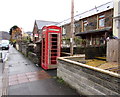
Red phonebox in Treherbert
On the north side of Bute Street 30 metres from the corner of Crichton Street.
Image: © Jaggery
Taken: 9 Nov 2017
0.05 miles
9
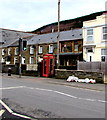
Red phonebox, Bute Street, Treherbert
Alongside the A4061 near a pelican crossing.
Image: © Jaggery
Taken: 6 Mar 2020
0.05 miles
10
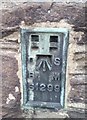
Ordnance Survey Flush Bracket (S1299)
This OS Flush Bracket can be found on the Bute Hotel. It marks a point 190.315m above mean sea level.
Image: © Adrian Dust
Taken: 28 Apr 2017
0.05 miles