IMAGES TAKEN NEAR TO
School Street, TREORCHY, CF42 5DU
Introduction
This page details the photographs taken nearby to School Street, CF42 5DU by members of the Geograph project.
The Geograph project started in 2005 with the aim of publishing, organising and preserving representative images for every square kilometre of Great Britain, Ireland and the Isle of Man.

There are currently over 7.5m images from over14,400 individuals and you can help contribute to the project by visiting https://www.geograph.org.uk
Image Map
Images are licensed for reuse under creativecommons.org/licenses/by-sa/2.0
Notes
- Clicking on the map will re-center to the selected point.
- The higher the marker number, the further away the image location is from the centre of the postcode.
Image Listing (32 Images Found)
Images are licensed for reuse under creativecommons.org/licenses/by-sa/2.0
Image
Details
Distance
1
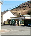
Blaencwm Community Centre
Single-storey building on Hendrewen Road, viewed from Dilys Street.
Image: © Jaggery
Taken: 23 Mar 2011
0.02 miles
2
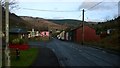
Hendrewen Road, Blaencwm
Looking down Hendrewen Road from the point where it changes to Michaels Road at the top of the village.
Image: © Helen
Taken: 6 Dec 2014
0.02 miles
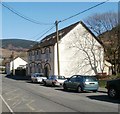
3
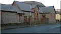
Former school, Blaencwm
This is the former school in Blaencwm which closed in 1999. It has since been converted into a house with a workshop to the rear.
Image: © Helen
Taken: 6 Dec 2014
0.03 miles
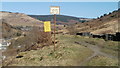
4
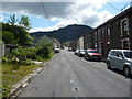
Part of the main street in Blaencwm
Looking south west up the street past the Hendrewen Hotel towards Cwm Selsig.
Image: © Jeremy Bolwell
Taken: 30 Jun 2011
0.03 miles
5

Blaencwm from above
The village looks very little in the valley bottom below.
Image: © Jeremy Bolwell
Taken: 30 Jun 2011
0.03 miles
6
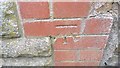
Ordnance Survey Cut Mark
This OS cut mark can be found on the school. It marks a point 219.072m above mean sea level.
Image: © Adrian Dust
Taken: 29 Apr 2017
0.03 miles
7
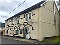
Hendrewen Hotel
Small hotel in Blaencwm.
Image: © Alan Hughes
Taken: 8 Aug 2019
0.05 miles
8
Hendrewen Hotel, Blaencwm
Located on Hendrewen Road. The hotel is located in Blaencwm, at the head the Rhondda Fawr valley, surrounded by wooded hillsides.
Image: © Jaggery
Taken: 23 Mar 2011
0.05 miles
9
Keep out ! Coal Authority land, Blaencwm
I of course remained on the safe, public side of the notices. Under a depiction of a skull and crossbones, the yellow notice warns of steep slippery slopes and risk of injury from sliding, falling and obstacles.
The notices are located on the hillside on the south side of Michael's Road, Blaencwm.
Image: © Jaggery
Taken: 23 Mar 2011
0.05 miles
10
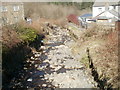
Nant Selsig, Blaencwm
A rock-strewn stream viewed from the eastern side of Delwen Terrace.
Image: © Jaggery
Taken: 23 Mar 2011
0.07 miles