IMAGES TAKEN NEAR TO
Treharne Street, PENTRE, CF41 7HX
Introduction
This page details the photographs taken nearby to Treharne Street, CF41 7HX by members of the Geograph project.
The Geograph project started in 2005 with the aim of publishing, organising and preserving representative images for every square kilometre of Great Britain, Ireland and the Isle of Man.

There are currently over 7.5m images from over14,400 individuals and you can help contribute to the project by visiting https://www.geograph.org.uk
Image Map
Images are licensed for reuse under creativecommons.org/licenses/by-sa/2.0
Notes
- Clicking on the map will re-center to the selected point.
- The higher the marker number, the further away the image location is from the centre of the postcode.
Image Listing (43 Images Found)
Images are licensed for reuse under creativecommons.org/licenses/by-sa/2.0
Image
Details
Distance
1
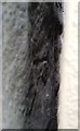
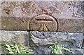
Ordnance Survey Cut Mark
This OS cut mark can be found behind the wall post of the Alexandra Hotel. It marks a point 153.592m above mean sea level.
Image: © Adrian Dust
Taken: 7 May 2017
0.03 miles
2
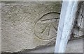
Ordnance Survey Cut Mark
This OS cut mark can be found on the Municipal Offices. It marks a point 168.050m above mean sea level.
Image: © Adrian Dust
Taken: 7 May 2017
0.10 miles
3
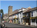
Pentre: Llewellyn Street Post Office
This office will close permanently on 26 February 2008.
Image: © Chris Downer
Taken: 18 Feb 2008
0.13 miles
4
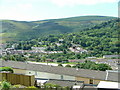
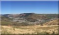
Pentre
A view across Pentre towards Ton Pentre
Image: © Nick Mutton 01329 000000
Taken: 8 Jul 2007
0.14 miles
5
Ordnance Survey Cut Mark
This OS cut mark can be found on St Peter's Church. It marks a point 170.989m above mean sea level.
Image: © Adrian Dust
Taken: 7 May 2017
0.15 miles
7
Rhondda Fawr
Panoramic view of the Rhondda Fawr, encompassing, from left to right, Treorchy, Ton Pentre, Pentre, Gelli and Ystrad, viewed from the pass between Mynydd Bwllfa and Mynydd Gelli.
Image: © Alan Hughes
Taken: 11 Apr 2019
0.16 miles
8
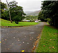
Unnamed road on the north side of Pentwyn Road, Ton Pentre
Descending towards the Rhondda River.
Image: © Jaggery
Taken: 8 Oct 2018
0.18 miles
9
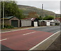
Maindy Crescent lockup garages, Ton Pentre
On the north side of the B4223 Maindy Crescent. The garage on the right is opposite Maindy Croft. https://www.geograph.org.uk/photo/5933304
Image: © Jaggery
Taken: 8 Oct 2018
0.18 miles
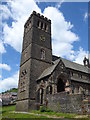
10
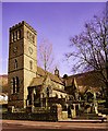
St Peters Church, Pentre, Rhondda Fawr Valley, South Wales
Built in 1890 at the height of the coal boom time in the Rhondda Valley.
St Peter's has a magnificent peal of 8 bells with the tenor a heavy 1,366kg.
The tower is over 100ft high.
Image: © Peter Brabham
Taken: 1 Nov 1998
0.18 miles