IMAGES TAKEN NEAR TO
Upper Canning Street, PENTRE, CF41 7HG
Introduction
This page details the photographs taken nearby to Upper Canning Street, CF41 7HG by members of the Geograph project.
The Geograph project started in 2005 with the aim of publishing, organising and preserving representative images for every square kilometre of Great Britain, Ireland and the Isle of Man.

There are currently over 7.5m images from over14,400 individuals and you can help contribute to the project by visiting https://www.geograph.org.uk
Image Map
Images are licensed for reuse under creativecommons.org/licenses/by-sa/2.0
Notes
- Clicking on the map will re-center to the selected point.
- The higher the marker number, the further away the image location is from the centre of the postcode.
Image Listing (108 Images Found)
Images are licensed for reuse under creativecommons.org/licenses/by-sa/2.0
Image
Details
Distance
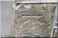
2
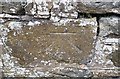
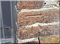
Ordnance Survey Cut Mark
This OS cut mark can be found on the wall NW side of The Parade. It marks a point 169.332m above mean sea level.
Image: © Adrian Dust
Taken: 7 May 2017
0.06 miles
3
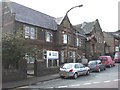
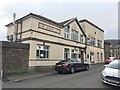
Ton Pentre police station
Located on the corner of Maindy Road and The Parade. The police station is part of the Rhondda Area of South Wales Police.
The inscription in stone on the left side of the building is COUNTY POLICE STATION AD 1909. On the right side is POLICE COURT AD 1909.
Image: © Jaggery
Taken: 3 Nov 2011
0.06 miles
4
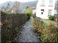
Nant Ian, Ton Pentre
Nant Ian flows away from Maindy Road, towards the Rhondda Fawr about 150 metres from the camera. On the left is Ton Pentre Junior School. Behind the camera is Ton Pentre police station. http://www.geograph.org.uk/photo/2678986
Image: © Jaggery
Taken: 3 Nov 2011
0.06 miles
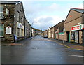
5
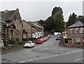
The Parade, Ton Pentre
From the B4223, The Parade ascends towards Maindy Grove.
Image: © Jaggery
Taken: 8 Oct 2018
0.07 miles
6
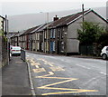
Zigzag yellow markings on the B4223, Ton Pentre
Marking the Keep Clear Zone outside Ton Pentre Junior School.
Image: © Jaggery
Taken: 8 Oct 2018
0.09 miles
7
Ordnance Survey Cut Mark
This OS cut mark can be found on the converted barn at Maindy Farm. It marks a point 187.958m above mean sea level.
Image: © Adrian Dust
Taken: 7 May 2017
0.09 miles
8
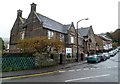
Conservative Club
Maindy Conservative Club, Ton Pentre.
Image: © Alan Hughes
Taken: 14 Apr 2017
0.09 miles
9
Ordnance Survey Cut Mark
This OS cut mark can be found on No1 Maindy Road. It marks a point 153.439m above mean sea level.
Image: © Adrian Dust
Taken: 7 May 2017
0.10 miles
10
Maindy Road, Ton Pentre
Maindy Road (B4223) heads away from Church Road. Fagins http://www.geograph.org.uk/photo/2678954 is on the left.
Image: © Jaggery
Taken: 3 Nov 2011
0.10 miles