IMAGES TAKEN NEAR TO
Pontrhondda Avenue, TONYPANDY, CF40 2TA
Introduction
This page details the photographs taken nearby to Pontrhondda Avenue, CF40 2TA by members of the Geograph project.
The Geograph project started in 2005 with the aim of publishing, organising and preserving representative images for every square kilometre of Great Britain, Ireland and the Isle of Man.

There are currently over 7.5m images from over14,400 individuals and you can help contribute to the project by visiting https://www.geograph.org.uk
Image Map
Images are licensed for reuse under creativecommons.org/licenses/by-sa/2.0
Notes
- Clicking on the map will re-center to the selected point.
- The higher the marker number, the further away the image location is from the centre of the postcode.
Image Listing (29 Images Found)
Images are licensed for reuse under creativecommons.org/licenses/by-sa/2.0
Image
Details
Distance
1
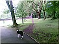
Educational site and sports field in Llwynypia from Penrhys Road, Ystrad
A school and college campus are on the left side of a rugby pitch and sports field.
Image: © Jaggery
Taken: 30 Mar 2015
0.05 miles
2
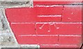
Ordnance Survey Cut Mark
This OS cut mark can be found on No172 Tyntyla Road. It marks a point 151.281m above mean sea level.
Image: © Adrian Dust
Taken: 7 May 2017
0.05 miles
3
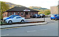
The Surgery, Tyntyla Road, Llwynypia
The surgery at 150 Tyntyla Road is set back from the west side of the road.
Image: © Jaggery
Taken: 28 Oct 2011
0.07 miles
4
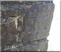
Ordnance Survey Cut Mark
This OS cut mark can be found on the wall at the bottom of the steps. It marks a point 154.744m above mean sea level.
Image: © Adrian Dust
Taken: 7 May 2017
0.11 miles
5
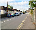
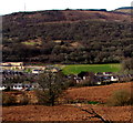
SE boundary of Ystrad
Tyntyla Road (A4058) crosses from Llwynypia into Ystrad. The nearby railway station is named Ystrad Rhondda to distinguish it from Ystrad Mynach (and from other communities named Ystrad).
Image: © Jaggery
Taken: 28 Oct 2011
0.11 miles
6
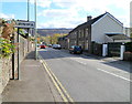
NW boundary of Llwynypia
The A4058 crosses from Ystrad into Llwynypia, a village in Rhondda Cynon Taf, near Tonypandy in the Rhondda Fawr Valley.
Image: © Jaggery
Taken: 28 Oct 2011
0.11 miles
7
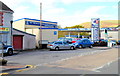
Triple Crown, Llwynypia
Car sales, MoT testing station and diagnostic centre, Tyntyla Road.
Kings Garden Chinese takeaway http://www.geograph.org.uk/photo/2791774 is on the left.
Image: © Jaggery
Taken: 28 Oct 2011
0.11 miles
8
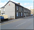
Llwynypia : Tyntyla Road houses between a garage and a surgery
The short row of houses on the west side of Tyntyla Road are between Triple Crown garage http://www.geograph.org.uk/photo/2791779 and a surgery. http://www.geograph.org.uk/photo/2791800
Image: © Jaggery
Taken: 28 Oct 2011
0.11 miles
9
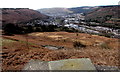
Valley view towards Llwynypia
Llwynypia in the valley of the Rhondda Fawr river viewed from this http://www.geograph.org.uk/photo/4419124 Penrhys bench.
In March 2015, the directions and locations information on the tablet in the
foreground have faded to illegibility.
Image: © Jaggery
Taken: 30 Mar 2015
0.11 miles