1
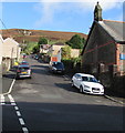
Top end of Maesyffynon Terrace, Trealaw
Maesyffynon Terrace ascends northwards from the Pinewood Drive
junction towards the right turn into Sycamore Drive.
Image: © Jaggery
Taken: 28 Sep 2017
0.02 miles
2
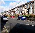
Up Maesyffynon Terrace, Trealaw
Maesyffynon Terrace ascends northwards from the corner of Rhys Street.
All Saints Church http://www.geograph.org.uk/photo/5556156 is on the right.
Image: © Jaggery
Taken: 28 Sep 2017
0.02 miles
3
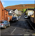
Back lane and path on the west side of Maesyffynon Terrace, Trealaw
Opposite the Pinewood Drive junction, http://www.geograph.org.uk/photo/5556101 the lower level lane on the left extends to Rhys Street.
The path on the right leads to the top end of Maesyffynon Terrace near Sycamore Drive.
Image: © Jaggery
Taken: 28 Sep 2017
0.02 miles
4
Pinewood Drive, Trealaw
Cul-de-sac on the east side of Maesyffynon Terrace.
Image: © Jaggery
Taken: 28 Sep 2017
0.04 miles
5
North side of Rhys Street, Trealaw
Viewed from the corner of Maesyffynon Terrace.
Image: © Jaggery
Taken: 28 Sep 2017
0.04 miles
6
All Saints Church, Rhys Street, Trealaw
Church in Wales church in the Diocese of Llandaff.
Image: © Jaggery
Taken: 28 Sep 2017
0.05 miles
7
Ordnance Survey Cut Mark
This OS cut mark can be found on No11 Rhys Street. It marks a point 152.086m above mean sea level.
Image: © Adrian Dust
Taken: 21 May 2017
0.05 miles
8
Maesyffynon Terrace, Trealaw
Ascending from the north side of Brithweunydd Road.
Image: © Jaggery
Taken: 28 Sep 2017
0.05 miles
9
Long row of houses, Rhys Street, Trealaw
Viewed across Maesyffynon Terrace.
Image: © Jaggery
Taken: 28 Sep 2017
0.06 miles
10
All Saints Church Hall, Rhys Street, Trealaw
The corrugated metal building is on the east side of All Saints Church http://www.geograph.org.uk/photo/5556156 on the left.
Image: © Jaggery
Taken: 28 Sep 2017
0.06 miles


