1
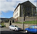
Zoar Residential Home, Clydach Vale
The Howard Street side of Zoar Residential Home on the corner of Marian Street.
The building is the much altered former Zoar chapel erected in 1881.
Image: © Jaggery
Taken: 5 Oct 2017
0.02 miles
2
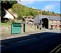
Up Marian Street, Clydach Vale
Marian Street ascends from the crossroads where Wern Street, Howard Street and Morton Terrace also meet.
Image: © Jaggery
Taken: 5 Oct 2017
0.02 miles
3
Zoar 1881 tablet, Clydach Vale
On the east side of the former Zoar chapel http://www.geograph.org.uk/photo/5560876 now converted to Zoar Residential Home. http://www.geograph.org.uk/photo/5560866
The Welsh text shows that Zoar was an Independent Chapel built in 1881.
I expected to see SOAR on the tablet as there is no Z in the standard Welsh alphabet.
Image: © Jaggery
Taken: 5 Oct 2017
0.02 miles
4
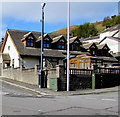
Marian Street houses, Clydach Vale
Above the north side of Howard Street.
Image: © Jaggery
Taken: 5 Oct 2017
0.02 miles
5
East side of the former Zoar chapel, Clydach Vale
The building is now Zoar Residential Home, http://www.geograph.org.uk/photo/5560866 much altered from when it was Zoar chapel, though this side of the building appears largely unaltered. A tablet http://www.geograph.org.uk/photo/5560883 records that the chapel was built in 1881.
Image: © Jaggery
Taken: 5 Oct 2017
0.02 miles
6
Howard Street bus stop and shelter, Clydach Vale
This stop near the corner of Marian Street is for buses to Tonypandy.
The Clydach Vale pub http://www.geograph.org.uk/photo/5560862 is on the right.
Image: © Jaggery
Taken: 5 Oct 2017
0.04 miles
7
Derelict building, Howard Street, Clydach Vale
Boards cover the windows in October 2017. An August 2012 Google Earth Street View is similar.
Image: © Jaggery
Taken: 5 Oct 2017
0.04 miles
8
Unnamed side road above Howard Street, Clydach Vale
Ascending to Marian Street.
Image: © Jaggery
Taken: 5 Oct 2017
0.04 miles
9
Morton Terrace, Clydach Vale
Ascending from the corner of Wern Street. The Clydach Vale pub http://www.geograph.org.uk/photo/5560862 is on the right.
Image: © Jaggery
Taken: 5 Oct 2017
0.04 miles
10
CCTV camera and telecoms cabinets on a Clydach Vale corner
A CCTV camera on a pole and a Virgin Media cabinet are on the Marian Street side of the corner.
A BT cabinet is on the Morton Terrace side.
Image: © Jaggery
Taken: 5 Oct 2017
0.04 miles


