IMAGES TAKEN NEAR TO
Oakdale Terrace, TONYPANDY, CF40 1RN
Introduction
This page details the photographs taken nearby to Oakdale Terrace, CF40 1RN by members of the Geograph project.
The Geograph project started in 2005 with the aim of publishing, organising and preserving representative images for every square kilometre of Great Britain, Ireland and the Isle of Man.

There are currently over 7.5m images from over14,400 individuals and you can help contribute to the project by visiting https://www.geograph.org.uk
Image Map
Images are licensed for reuse under creativecommons.org/licenses/by-sa/2.0
Notes
- Clicking on the map will re-center to the selected point.
- The higher the marker number, the further away the image location is from the centre of the postcode.
Image Listing (142 Images Found)
Images are licensed for reuse under creativecommons.org/licenses/by-sa/2.0
Image
Details
Distance
1
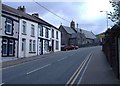
Penrhiwfer Road, Penrhiwfer
The church at the top of the street, is St Illtyd's.
Image: © Roger Cornfoot
Taken: 25 Apr 2007
0.01 miles
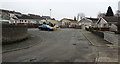
2
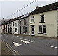
Speed bump opposite Oakdale Terrace, Penrhiwfer
Painted white triangles draw attention to the speed bump across the B4278 Penrhiwfer Road.
Image: © Jaggery
Taken: 3 Nov 2017
0.02 miles
3
Church Terrace, Penrhiwfer
Houses alongside Penrhiwfer Road north of the Church Road junction on the left.
Image: © Jaggery
Taken: 3 Nov 2017
0.02 miles
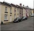
4
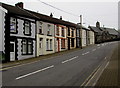
Oakdale Terrace, Penrhiwfer
Row of houses extending for 45 metres along the east side of the B4278 Penrhiwfer Road.
St Illtyd's Church http://www.geograph.org.uk/photo/5589542 is in the background.
Image: © Jaggery
Taken: 3 Nov 2017
0.02 miles
5
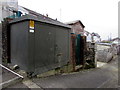
St Illtyd's electricity substation, Oakdale Road, Penrhiwfer
The Western Power Distribution electricity substation, identifier ST ILLTYDS PENRHIWFER S/S 542260
is on the corner of Oakdale Road and a back lane. St Illtyd's Church http://www.geograph.org.uk/photo/5589558 is nearby.
Image: © Jaggery
Taken: 3 Nov 2017
0.02 miles
6
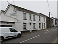
White houses and white van, Penrhiwfer Road, Penrhiwfer
The name on the side wall is PRECISE ENGINEERING LTD.
Image: © Jaggery
Taken: 3 Nov 2017
0.03 miles
7
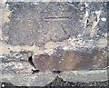
Ordnance Survey Cut Mark
This OS cut mark can be found on the wall of St Illtyd's Church. It marks a point 203.293m above mean sea level.
Image: © Adrian Dust
Taken: 21 May 2017
0.03 miles
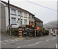
8
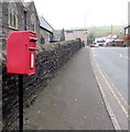
Queen Elizabeth II postbox on a Penrhiwfer corner
On the Penrhiwfer Road side of the Oakdale Road corner. St Illtyd's Church http://www.geograph.org.uk/photo/5589542 is in the background.
Image: © Jaggery
Taken: 3 Nov 2017
0.03 miles
9
Oakdale Road houses, Penrhiwfer
Row of houses on the south side of Oakfield Road on the ascent towards the B4278 Penrhiwfer Road.
Image: © Jaggery
Taken: 3 Nov 2017
0.03 miles
10
Oakdale Road bungalows, Penrhiwfer
Bungalows alongside a dead-end part of Oakdale Road, on the north side of the main part of Oakdale Road.
Image: © Jaggery
Taken: 3 Nov 2017
0.03 miles