IMAGES TAKEN NEAR TO
Nantgwyn Street, TONYPANDY, CF40 1LS
Introduction
This page details the photographs taken nearby to Nantgwyn Street, CF40 1LS by members of the Geograph project.
The Geograph project started in 2005 with the aim of publishing, organising and preserving representative images for every square kilometre of Great Britain, Ireland and the Isle of Man.

There are currently over 7.5m images from over14,400 individuals and you can help contribute to the project by visiting https://www.geograph.org.uk
Image Map (174 Images)


Leaflet Map data © OpenStreetMap
Images are licensed for reuse under creativecommons.org/licenses/by-sa/2.0
Notes
- Clicking on the map will re-center to the selected point.
- The higher the marker number, the further away the image location is from the centre of the postcode.
Image Listing (174 Images Found)
Images are licensed for reuse under creativecommons.org/licenses/by-sa/2.0
Image
Details
Distance
1
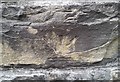
Ordnance Survey Cut Mark
This inverted OS cut mark can be found on the school wall. It marks a point 174.480m above mean sea level.
Image: © Adrian Dust
Taken: 21 May 2017
0.07 miles
2
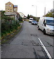
Hughes Street, Penygraig
Ascending from Tylacelyn Road.
Image: © Jaggery
Taken: 17 Oct 2017
0.07 miles
3
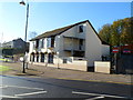
The Welcome Inn, Tonypandy
Pub located at the junction of Dunraven Street and Tylacelyn Road.
Image: © Jaggery
Taken: 28 Oct 2011
0.08 miles
4
Corner of Adare Terrace and Dunraven Street, Tonypandy
No entry signs prevent vehicular access to Adare Terrace from Dunraven Street.
Image: © Jaggery
Taken: 28 Oct 2011
0.08 miles
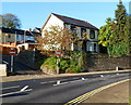
5
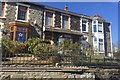
Tylacelyn Road
Terraced houses in Tylacelyn Road, Tonypandy.
Image: © Alan Hughes
Taken: 11 Apr 2019
0.09 miles
6
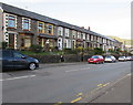
Long row of houses, Tylacelyn Road, Penygraig
Extending for 75 metres to the corner of Hughes Street.
Image: © Jaggery
Taken: 17 Oct 2017
0.09 miles
7
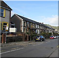
West side of Tylacelyn Road, Penygraig
Long row of houses extending for 75 metres to the corner of Hughes Street.
Penygraig RFC clubhouse http://www.geograph.org.uk/photo/5576993 is on the left.
Image: © Jaggery
Taken: 17 Oct 2017
0.09 miles
8
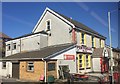
Penygraig RFC
Penygraig Rugby Football Club.
Image: © Alan Hughes
Taken: 11 Apr 2019
0.10 miles
9
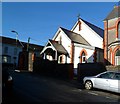
Church of SS Gabriel and Raphael, Tonypandy
Located on the corner of Trinity Road and Primrose Street.
The Roman Catholic SS (Saints) Gabriel and Raphael is the church for the Rhondda Parish, covering all of the Rhondda Fach and Rhondda Fawr except for Ynyshir. The building on the right is the presbytery. http://www.geograph.org.uk/photo/2668968
Image: © Jaggery
Taken: 28 Oct 2011
0.10 miles
10
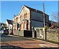
Presbytery, SS Gabriel and Raphael church, Tonypandy
The presbytery (priests' house) is on Trinity Road, next door to the church. http://www.geograph.org.uk/photo/2668962
Image: © Jaggery
Taken: 28 Oct 2011
0.10 miles