1
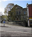
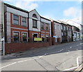
East side of the former Soar Baptist Chapel, Penygraig
This is the 1902 rebuild of Soar Baptist Chapel dating from 1832.
The chapel closed in 1978. In 2017 the building is in secular use as the Soar Centre.
Image: © Jaggery
Taken: 20 Oct 2017
0.00 miles
2
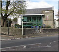
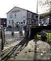
South side of the Soar Centre, Penygraig
In the converted former Soar Chapel. Depictions of two penny-farthing bicycles https://www.geograph.org.uk/photo/6109412 are between the walls. The wide variety of activities in the Soar Centre include coffee mornings, community bingo, positive parenting and counselling sessions. From 4pm on school days, many under 8s use the After School Club.
Image: © Jaggery
Taken: 20 Oct 2017
0.01 miles
3
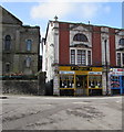
Caffeine in Penygraig
Cafe at 73 Tylacelyn Road.
Image: © Jaggery
Taken: 20 Oct 2017
0.01 miles
4
Soar, Tylacelyn Road, Pen-y-graig
Image: © Roger Cornfoot
Taken: 25 Apr 2007
0.01 miles
5
Zeus Barbers, Tylacelyn Road, Penygraig
Turkish barbers next door to the Old Library. http://www.geograph.org.uk/photo/5575012
Image: © Jaggery
Taken: 20 Oct 2017
0.01 miles
6
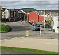
Towards the centre of the village from Amos Hill, Penygraig
Looking towards shops in Tylacelyn Road.
Image: © Jaggery
Taken: 20 Oct 2017
0.01 miles
7
Soar Centre, Penygraig
Formerly Soar Welsh Baptist Chapel.
https://www.coflein.gov.uk/en/site/10289/details/soar-welsh-baptist-chapel-soar-ffrwyd-soar-dinas-penygraig-road-penygraig
Image: © Alan Hughes
Taken: 11 Apr 2019
0.01 miles
8
Direction sign in Penygraig three-quarters of a mile from Tonypandy
The black arrow points left towards Tylacelyn Road.
Image: © Jaggery
Taken: 20 Oct 2017
0.01 miles
9
The Old Library, Tylacelyn Road, Penygraig
In October 2017, the turquoise information board centre right shows
Valley Kids Charity Shop - Book Swap - Computers - COFFI RED.
More than a shop - Everybody Welcome - Come in and Browse.
Image: © Jaggery
Taken: 20 Oct 2017
0.02 miles
10
Penny-farthing depictions, Penygraig
Located here https://www.geograph.org.uk/photo/6109411 at the edge of the Soar Centre. The penny-farthing, also known as the ordinary, was the first machine to be called a bicycle. It was popular in the 1870s and 1880s. It became obsolete in the late 1880s with the development of modern bicycles.
Image: © Jaggery
Taken: 20 Oct 2017
0.02 miles


