IMAGES TAKEN NEAR TO
Ffrwd Amos Industrial Estate, TONYPANDY, CF40 1HZ
Introduction
This page details the photographs taken nearby to Ffrwd Amos Industrial Estate, CF40 1HZ by members of the Geograph project.
The Geograph project started in 2005 with the aim of publishing, organising and preserving representative images for every square kilometre of Great Britain, Ireland and the Isle of Man.

There are currently over 7.5m images from over14,400 individuals and you can help contribute to the project by visiting https://www.geograph.org.uk
Image Map
Images are licensed for reuse under creativecommons.org/licenses/by-sa/2.0
Notes
- Clicking on the map will re-center to the selected point.
- The higher the marker number, the further away the image location is from the centre of the postcode.
Image Listing (195 Images Found)
Images are licensed for reuse under creativecommons.org/licenses/by-sa/2.0
Image
Details
Distance
1
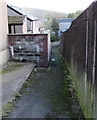
Eastern end of Station Street, Penygraig
Viewed from Tylacelyn Road opposite the main part of Station Street. http://www.geograph.org.uk/photo/5577139
Shown on maps as the eastern end of Station Street, this is a narrow lane which gets narrower ahead.
Image: © Jaggery
Taken: 17 Oct 2017
0.05 miles
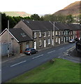
2
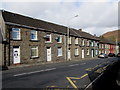
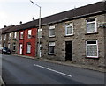
Grovefield Terrace, Penygraig
Row of houses extending for 60 metres along the west side of the B4278 Dinas Road.
Image: © Jaggery
Taken: 17 Oct 2017
0.06 miles
3
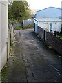
Unnamed side road in Penygraig
From the east side of Tylacelyn Road towards the southwest corner of Graig Park (out of shot on the left), the home ground of Penygraig RFC (Rugby Football Club).
Image: © Jaggery
Taken: 17 Oct 2017
0.06 miles
4
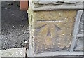
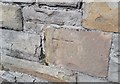
Ordnance Survey Cut Mark
This OS cut mark can be found on No30 Tylacelyn Road. It marks a point 153.110m above mean sea level.
Image: © Adrian Dust
Taken: 21 May 2017
0.07 miles
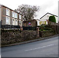
5
Conspicuous house in Grovefield Terrace, Penygraig
A non-grey house in a long row of houses on the west side of the B4278 Dinas Road.
Image: © Jaggery
Taken: 17 Oct 2017
0.07 miles
6
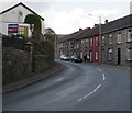
Bend in the B4278 Dinas Road, Penygraig
On the ascent towards the centre of the village, Dinas Road bends past houses in Grovefield Terrace.
Image: © Jaggery
Taken: 17 Oct 2017
0.07 miles
7
Ordnance Survey Cut Mark
This OS cut mark can be found on No9 Grovefield Terrace. It marks a point 142.893m above mean sea level.
Image: © Adrian Dust
Taken: 21 May 2017
0.07 miles
8
Warning sign - School/Ysgol, Dinas Road, Penygraig
The English/Welsh sign faces the B4278 Dinas Road on the approach to Tai Educational Centre.
Image: © Jaggery
Taken: 17 Oct 2017
0.07 miles
9
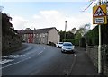
Down Dinas Road, Penygraig
On its descent to the A4058, the B4278 Dinas Road passes Grovefield Terrace.
Image: © Jaggery
Taken: 17 Oct 2017
0.07 miles
10
Houses above a bend in Dinas Road, Penygraig
Viewed across the B4278 Dinas Road.
Image: © Jaggery
Taken: 17 Oct 2017
0.07 miles