IMAGES TAKEN NEAR TO
Carn-y-Celyn Close, TONYPANDY, CF40 1DZ
Introduction
This page details the photographs taken nearby to Carn-y-Celyn Close, CF40 1DZ by members of the Geograph project.
The Geograph project started in 2005 with the aim of publishing, organising and preserving representative images for every square kilometre of Great Britain, Ireland and the Isle of Man.

There are currently over 7.5m images from over14,400 individuals and you can help contribute to the project by visiting https://www.geograph.org.uk
Image Map
Images are licensed for reuse under creativecommons.org/licenses/by-sa/2.0
Notes
- Clicking on the map will re-center to the selected point.
- The higher the marker number, the further away the image location is from the centre of the postcode.
Image Listing (129 Images Found)
Images are licensed for reuse under creativecommons.org/licenses/by-sa/2.0
Image
Details
Distance
1
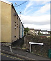
Row of houses on the north side of Pleasant Road, Penygraig
The sign shows 7-11 PLEASANT ROAD.
Image: © Jaggery
Taken: 20 Oct 2017
0.12 miles
2

Ordnance Survey Cut Mark
This OS cut mark can be found on No1 Railway Terrace. It marks a point 170.252m above mean sea level.
Image: © Adrian Dust
Taken: 21 May 2017
0.12 miles
3
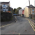
Pleasant Road, Penygraig
Pleasant Road ascends from Penygraig Road. Penygraig Convenience Store http://www.geograph.org.uk/photo/5575945 is on the left.
Image: © Jaggery
Taken: 20 Oct 2017
0.12 miles
4
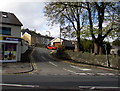
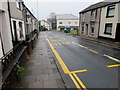
Up Pleasant Road, Penygraig
From the B4278, Pleasant Road ascends towards Gethin Road.
Double yellow lines on both sides of the road indicate no parking at any time.
Image: © Jaggery
Taken: 20 Oct 2017
0.13 miles
5
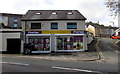
Penygraig Convenience Store, Penygraig
Premier store at 104 Penygraig Road on the corner of Pleasant Road.
Image: © Jaggery
Taken: 20 Oct 2017
0.13 miles
6
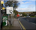
Directions sign, Penygraig Road, Penygraig
Facing southbound traffic on the B4278 Penygraig Road on the approach to a roundabout.
Image: © Jaggery
Taken: 20 Oct 2017
0.13 miles
7
Penygraig Road bus stop, Penygraig
This side of the B4278 Penygraig Road for buses to Tonypandy.
Image: © Jaggery
Taken: 26 Oct 2017
0.13 miles
8
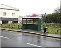
Labour Club bus stop and shelter, Penygraig
Alongside the B4278 Penygraig Road near Penygraig Labour Club. https://www.geograph.org.uk/photo/5575970 In October 2017, the bus stop sign shows four routes - 122 to Cardiff via Royal Glamorgan Hospital & Talbot Green, 152 to Tonyrefail, 153 to Gilfach Goch & Evanstown, 172 to Bridgend & Porthcawl.
Image: © Jaggery
Taken: 26 Oct 2017
0.13 miles
9
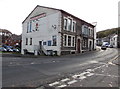
Penygraig Labour Club, 11 Penygraig Road, Penygraig
The plaque http://www.geograph.org.uk/photo/5575979 on the wall above the main entrance shows
"LABOUR PROGRESSIVE CLUB EST'D 1904 REBUILT 1912" (EST'D = ESTABLISHED).
Image: © Jaggery
Taken: 20 Oct 2017
0.13 miles
10
Penygraig Road houses, Penygraig
On the east side of the B4278 Penygraig Road southeast of Tonypandy.
Image: © Jaggery
Taken: 26 Oct 2017
0.13 miles