IMAGES TAKEN NEAR TO
Adare Terrace, TONYPANDY, CF40 1DJ
Introduction
This page details the photographs taken nearby to Adare Terrace, CF40 1DJ by members of the Geograph project.
The Geograph project started in 2005 with the aim of publishing, organising and preserving representative images for every square kilometre of Great Britain, Ireland and the Isle of Man.

There are currently over 7.5m images from over14,400 individuals and you can help contribute to the project by visiting https://www.geograph.org.uk
Image Map
Images are licensed for reuse under creativecommons.org/licenses/by-sa/2.0
Notes
- Clicking on the map will re-center to the selected point.
- The higher the marker number, the further away the image location is from the centre of the postcode.
Image Listing (189 Images Found)
Images are licensed for reuse under creativecommons.org/licenses/by-sa/2.0
Image
Details
Distance
1
Waste ground, Dunraven Street, Tonypandy
Viewed in October 2017. The Cinema Treasures website records that in the early 20th century this was the location of the Hippodrome Cinema. It was converted to a music hall and cinema in 1912. Renamed twice in the 1930s - first to New Hippodrome Cinema then Plaza Cinema towards the end of the 1930s.
Converted to a bingo club in the 1960s. After Tonypandy's Picturedrome cinema closed in 1969, the Plaza was reopened as a cinema. After the Plaza Cinema closed for the last time in June 1983, the building was converted to a full time bingo club which was in business for about two decades.
Image: © Jaggery
Taken: 17 Oct 2017
0.01 miles
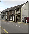
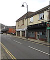
2
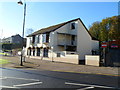
The Welcome Inn, Tonypandy
Pub located at the junction of Dunraven Street and Tylacelyn Road.
Image: © Jaggery
Taken: 28 Oct 2011
0.02 miles
3
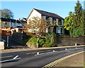
Corner of Adare Terrace and Dunraven Street, Tonypandy
No entry signs prevent vehicular access to Adare Terrace from Dunraven Street.
Image: © Jaggery
Taken: 28 Oct 2011
0.02 miles
4

Former Trinity Calvinistic Methodist Church, Tonypandy
The Dunraven Street side of the former church on the corner of Trinity Road, viewed in October 2017.
The building dates from 1893. Some sources show Chapel instead of Church.
Image: © Jaggery
Taken: 17 Oct 2017
0.03 miles
5
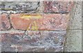
Ordnance Survey Cut Mark
This OS cut mark can be found on the only still standing part of the old cinema. It marks a point 132.481m above mean sea level.
Image: © Adrian Dust
Taken: 13 May 2017
0.03 miles
6
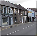
L.K.Barbers, Dunraven Street, Tonypandy
Text on the nameboard shows that L is for Levi and K for Kelly.
Image: © Jaggery
Taken: 17 Oct 2017
0.04 miles
7
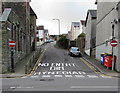
Up Trinity Road, Tonypandy
Trinity Road ascends from Dunraven Street. English and Welsh words painted
on the road surface repeat the message conveyed by the wordless No Entry signs.
Image: © Jaggery
Taken: 17 Oct 2017
0.04 miles
8
Ornate gates, Dunraven Street, Tonypandy
On the right here http://www.geograph.org.uk/photo/5573270 outside the former Trinity Calvinistic Methodist Church, viewed in October 2017.
The words ONE LOVE are in the arch above the gates.
No gates or arch were here in a July 2016 Google Earth Street View.
Image: © Jaggery
Taken: 17 Oct 2017
0.04 miles
9
Dunraven Street houses and a shop, Tonypandy
L.K.Barbers shop http://www.geograph.org.uk/photo/5571742 is on the left.
Image: © Jaggery
Taken: 17 Oct 2017
0.04 miles
10
Revamp in Tonypandy
Revamp hair & beauty salon viewed across Dunraven Street.
Oxford House http://www.geograph.org.uk/photo/5571512 next door is on the corner of Bridge Street.
Image: © Jaggery
Taken: 17 Oct 2017
0.04 miles