IMAGES TAKEN NEAR TO
Birchgrove Street, PORTH, CF39 9YA
Introduction
This page details the photographs taken nearby to Birchgrove Street, CF39 9YA by members of the Geograph project.
The Geograph project started in 2005 with the aim of publishing, organising and preserving representative images for every square kilometre of Great Britain, Ireland and the Isle of Man.

There are currently over 7.5m images from over14,400 individuals and you can help contribute to the project by visiting https://www.geograph.org.uk
Image Map
Images are licensed for reuse under creativecommons.org/licenses/by-sa/2.0
Notes
- Clicking on the map will re-center to the selected point.
- The higher the marker number, the further away the image location is from the centre of the postcode.
Image Listing (91 Images Found)
Images are licensed for reuse under creativecommons.org/licenses/by-sa/2.0
Image
Details
Distance
1
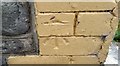
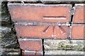
Ordnance Survey Cut Mark
This OS cut mark can be found on No104 Charles Street. It marks a point 129.232m above mean sea level.
Image: © Adrian Dust
Taken: 4 Jun 2017
0.03 miles
2
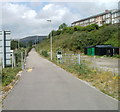
National Cycle Route 881, Porth
Here named the Rhondda Fach Trail, the combined footpath and cycleway heads north towards Ynyshir, Wattstown and Maerdy. The route behind the camera leads into central Porth and on to Pontypridd.
Image: © Jaggery
Taken: 6 May 2011
0.09 miles
3
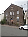
Capel Seion, Porth
Welsh Baptist chapel. Now closed
Image: © John Lord
Taken: 12 Jul 2016
0.09 miles
5
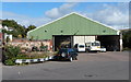
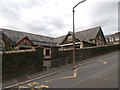
Bus depot, Aberrhondda Road, Porth
This is the southern end of a 75 metre long building set back 60 metres from Aberrhondda Road. Formerly the National Welsh bus depot, it is now the premises of Thomas Coaches. Founded in 1967 by Walter Glyn Thomas, the company specialises in providing high specification single deck and double deck vehicles for use by the travel industry.
Image: © Jaggery
Taken: 19 Sep 2012
0.11 miles
6
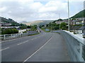
A4233, Porth
Viewed from the northern side of Rheola Bridge, http://www.geograph.org.uk/photo/2612372 the A4233 heads towards Ynyshir.
Image: © Jaggery
Taken: 6 May 2011
0.12 miles
7
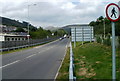
No pedestrians beyond this point, A4233, Porth
Pedestrians can cross the Rheola Bridge http://www.geograph.org.uk/photo/2612363 (behind the camera), but this is as far as they are allowed to go along the A4233. Out of shot on the right is a combined footpath and cycleway. http://www.geograph.org.uk/photo/2612587
Image: © Jaggery
Taken: 6 May 2011
0.12 miles
9
Ordnance Survey Cut Mark
This OS cut mark can be found on the wall of No33 Coronation Terrace. It marks a point 134.704m above mean sea level.
Image: © Adrian Dust
Taken: 4 Jun 2017
0.12 miles