IMAGES TAKEN NEAR TO
Cross Street, PORTH, CF39 9SS
Introduction
This page details the photographs taken nearby to Cross Street, CF39 9SS by members of the Geograph project.
The Geograph project started in 2005 with the aim of publishing, organising and preserving representative images for every square kilometre of Great Britain, Ireland and the Isle of Man.

There are currently over 7.5m images from over14,400 individuals and you can help contribute to the project by visiting https://www.geograph.org.uk
Image Map
Images are licensed for reuse under creativecommons.org/licenses/by-sa/2.0
Notes
- Clicking on the map will re-center to the selected point.
- The higher the marker number, the further away the image location is from the centre of the postcode.
Image Listing (230 Images Found)
Images are licensed for reuse under creativecommons.org/licenses/by-sa/2.0
Image
Details
Distance
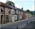
1
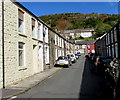
Cross Street, Porth
From the corner of John Street along Cross Street to North Road.
Image: © Jaggery
Taken: 5 Oct 2017
0.02 miles
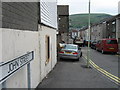
2
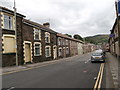
North Rd, Porth
The houses are numbered consecutively along the north side of the street from west to east, then back along the south side from east to west, so that Nos 1 and 123 (Humphreys Funeral Directors, purple sign on the right of the picture) are opposite each other.
Image: © John Lord
Taken: 12 Jul 2016
0.02 miles
3
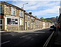
North Street, Porth
Ahead is a one-way section of the B4278. Silver Star takeaway http://www.geograph.org.uk/photo/5562128 is on the left.
Image: © Jaggery
Taken: 5 Oct 2017
0.02 miles
4
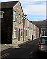
Row of houses, John Street, Porth
Ahead for Porth railway station on the Rhondda Line.
Image: © Jaggery
Taken: 5 Oct 2017
0.03 miles
5
One-way traffic, North Road, Porth
Looking SE along North Road past the Cross Street junction. The arrow on a one-way sign facing Cross Street points to the right.
Image: © Jaggery
Taken: 6 May 2011
0.03 miles
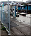
6
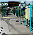
Rhondda Fach Trail along the edge of Porth railway station
The Rhondda Fach Trail, a footpath and cycleway, passes from Syphon Street http://www.geograph.org.uk/photo/3615238 to this route between the green fences alongside the railway station. A blue sign behind the noticeboards gives the distances to Maerdy, Wattstown and Ynyshir along the Rhondda Fach Trail.
Image: © Jaggery
Taken: 20 Aug 2013
0.03 miles
8
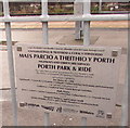
Porth Park & Ride plaque, Porth railway station
The plaque at the Syphon Street entrance http://www.geograph.org.uk/photo/5565878 to the station records the official opening of Porth Park & Ride on September 22nd 2016. The Rhondda Cynon Taf council website states
"The aim of the scheme was to attract car users from the wide surrounding catchment and enable them to use the train for the main part of their journey to their final destination, particularly avoiding the congested routes, such as the A4054 into Pontypridd and the A470 into Cardiff. The facility has already made a big difference to commuters, with lots of positive feedback received.
The new facility has improved the area's transport infrastructure, by encouraging more people to use public transport, which will in turn deliver more sustainable access to jobs and services."
Image: © Jaggery
Taken: 10 Oct 2017
0.04 miles
9
Porth railway station plaque
The plaque http://www.geograph.org.uk/photo/5565869 on the railings records the official opening of Porth Park & Ride in September 2016.
Image: © Jaggery
Taken: 10 Oct 2017
0.04 miles
10
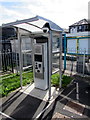
Ticket machine at Porth railway station
The screen displays This is the new TicketXpress machine! PLEASE TOUCH THE SCREEN.
Image: © Jaggery
Taken: 5 Oct 2017
0.04 miles