IMAGES TAKEN NEAR TO
Foundry Place, PORTH, CF39 9PN
Introduction
This page details the photographs taken nearby to Foundry Place, CF39 9PN by members of the Geograph project.
The Geograph project started in 2005 with the aim of publishing, organising and preserving representative images for every square kilometre of Great Britain, Ireland and the Isle of Man.

There are currently over 7.5m images from over14,400 individuals and you can help contribute to the project by visiting https://www.geograph.org.uk
Image Map
Images are licensed for reuse under creativecommons.org/licenses/by-sa/2.0
Notes
- Clicking on the map will re-center to the selected point.
- The higher the marker number, the further away the image location is from the centre of the postcode.
Image Listing (161 Images Found)
Images are licensed for reuse under creativecommons.org/licenses/by-sa/2.0
Image
Details
Distance
2
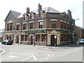
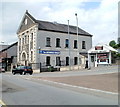
Llwyncelyn Hotel, Porth
Large pub on the corner of North Road and Llwyncelyn Road. There is a restaurant, and a function room for hire, accommodating about 50 people.
Image: © Jaggery
Taken: 6 May 2011
0.03 miles
3
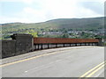
Railway bridge, central Porth
The bridge is part of a 70-metre long unnamed road connecting North Road and Llwyncelyn Road behind the camera with Pontypridd Road ahead. Under the bridge is the two-track Rhondda Line, about 300 metres SE of Porth railway station.
Image: © Jaggery
Taken: 6 May 2011
0.03 miles
4
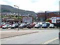
Chequered Flag, Porth
User car dealers' premises on Pontypridd Road.
Image: © Jaggery
Taken: 6 May 2011
0.03 miles
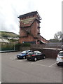
5
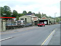
S&F Motors Ltd, Porth
Accident repair specialists, located on Pontypridd Road,near Eirw-uchaf Bridge over the River Rhondda.
Image: © Jaggery
Taken: 6 May 2011
0.03 miles
6
The Gatehouse Church, Porth
Located on Pontypridd Road. The church opened in 1903 as Ebenezer Welsh Wesleyan Methodist.
The small single-storey building on the right is Knock-out Barbers.
Image: © Jaggery
Taken: 6 May 2011
0.03 miles
7
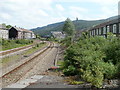
A view SE from Porth railway station
On the left are Syphon Street houses; on the right, West Taff Street houses.
Porth station is on the Rhondda Line (Cardiff to Treherbert).
Image: © Jaggery
Taken: 6 May 2011
0.03 miles
8
Porth Library
Part of Rhondda Cynon Taf library service, located on Pontypridd Road.
Image: © Jaggery
Taken: 6 May 2011
0.03 miles
9
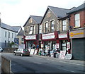
Rhondda Household, Porth
Old-style ironmongers and DiY store on Pontypridd Road, opposite Porth Library. http://www.geograph.org.uk/photo/2456092
Image: © Jaggery
Taken: 6 May 2011
0.03 miles
10
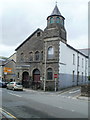
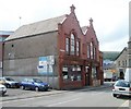
United Reformed Church, Porth
Located on Pontypridd Road, opposite the Porth Plaza building.
The original congregation was named Porth English Congregational Church (founded in 1881).
The church building seen here opened for worship in 1885. In 1972 it became part of the United Reformed Church, which includes churches from the Congregational, Presbyterian and Disciples traditions in England, Scotland and Wales.
Image: © Jaggery
Taken: 6 May 2011
0.03 miles