IMAGES TAKEN NEAR TO
Bedw Street, PORTH, CF39 9LD
Introduction
This page details the photographs taken nearby to Bedw Street, CF39 9LD by members of the Geograph project.
The Geograph project started in 2005 with the aim of publishing, organising and preserving representative images for every square kilometre of Great Britain, Ireland and the Isle of Man.

There are currently over 7.5m images from over14,400 individuals and you can help contribute to the project by visiting https://www.geograph.org.uk
Image Map
Images are licensed for reuse under creativecommons.org/licenses/by-sa/2.0
Notes
- Clicking on the map will re-center to the selected point.
- The higher the marker number, the further away the image location is from the centre of the postcode.
Image Listing (93 Images Found)
Images are licensed for reuse under creativecommons.org/licenses/by-sa/2.0
Image
Details
Distance
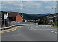
1
Glynfach Road, Cymmer, Porth
Viewed from the edge of The Rhondda. http://www.geograph.org.uk/photo/4096532
Image: © Jaggery
Taken: 30 Jul 2014
0.02 miles
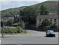
2
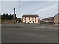
A4233 heads east away from Cymmer, Porth
Destinations shown on the sign on the left are Aberdare, Pontypridd and Porth town centre.
Image: © Jaggery
Taken: 30 Jul 2014
0.05 miles
3
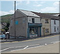
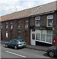
The Cwtch, High Street, Cymmer, Porth
The Cwtch provides a repair & alterations service, and sells soft furnishings and "shabby chic" gifts. Mr Frank Cottle, who was born in Cymmer, remembers that the shop was Lloyds the butchers when he left the area in 1956.
Image: © Jaggery
Taken: 30 Jul 2014
0.05 miles
4
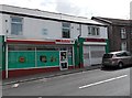
Spar, Cymmer, Porth
The Spar shop is at 36 High Street, Cymmer, Porth.
The name on the shuttered shop on the right is CAPITAL VIDEO.
Image: © Jaggery
Taken: 30 Jul 2014
0.05 miles
6
Salonfortyone, Cymmer, Porth
Salonfortyone is a hair salon at 41 High Street, Cymmer, Porth.
Image: © Jaggery
Taken: 30 Jul 2014
0.06 miles
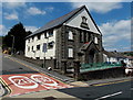
7
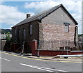
Decaying former Cymmer Chapel, Porth
Located in High Street, opposite The Rhondda. http://www.geograph.org.uk/photo/4096532 Partly hidden by weeds in July 2014, a blue plaque is on the wall on the left side of the fenced-off building. It records that Cymmer Chapel, built in 1743, rebuilt in 1834, was the earliest Nonconformist Chapel built in the Rhondda Valleys.
Image: © Jaggery
Taken: 30 Jul 2014
0.06 miles
8
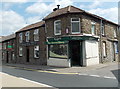
The Corner Shop and Cymmer Fish Bar, Cymmer, Porth
On the corner of High Street and Brook Street, The Corner Shop shows
the name W.R.G.Lewis over the doorway. Cymmer Fish Bar is on the left.
Image: © Jaggery
Taken: 30 Jul 2014
0.07 miles
9

Ordnance Survey Cut Mark
This OS cut mark can be found on No46 High Street. It marks a point 123.008m above mean sea level.
Image: © Adrian Dust
Taken: 27 May 2018
0.07 miles
10
Flats in a converted former chapel in Cymmer, Porth
The building is on the corner of High Street and Catherine Crescent.
An inscription in Welsh on a wall shows that the building was erected in 1907
as Caersalem Newydd (New Jerusalem) chapel.
Image: © Jaggery
Taken: 30 Jul 2014
0.07 miles