IMAGES TAKEN NEAR TO
Cwrt Y Mynydd, PORTH, CF39 9DW
Introduction
This page details the photographs taken nearby to Cwrt Y Mynydd, CF39 9DW by members of the Geograph project.
The Geograph project started in 2005 with the aim of publishing, organising and preserving representative images for every square kilometre of Great Britain, Ireland and the Isle of Man.

There are currently over 7.5m images from over14,400 individuals and you can help contribute to the project by visiting https://www.geograph.org.uk
Image Map
Images are licensed for reuse under creativecommons.org/licenses/by-sa/2.0
Notes
- Clicking on the map will re-center to the selected point.
- The higher the marker number, the further away the image location is from the centre of the postcode.
Image Listing (25 Images Found)
Images are licensed for reuse under creativecommons.org/licenses/by-sa/2.0
Image
Details
Distance
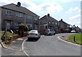
1
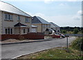
Cwrt-y-mynydd, Trebanog
Recently-built houses set back from the A4233 Trebanog Road.
Image: © Jaggery
Taken: 30 Jul 2014
0.01 miles
2
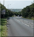
Road from Trebanog to Tonyrefail
The A4233 descends to the SSW, away from Trebanog.
Image: © Jaggery
Taken: 30 Jul 2014
0.03 miles
3
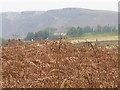
A view of Trebanog from the Waen and the mountains above Edmundstown
Image: © Clive Thomas
Taken: 16 Sep 2008
0.04 miles
4
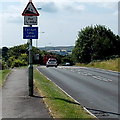
Escape lane ahead, Trebanog
The sign is alongside the A4233 at the top of a ¾ mile section of road with an average descent gradient of 8% (between 1 in 12 and 1 in 13). An escape lane is usually filled with gravel or a similar loose material to absorb the energy of a vehicle with failed brakes, and bring it to a stop.
Image: © Jaggery
Taken: 30 Jul 2014
0.04 miles
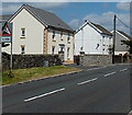
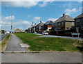
5
Houses set back from Trebanog Road, Trebanog
Separated from the A4233 Trebanog Road by the grass strip on the right,
most of these houses are about 25 metres east of the main road.
Image: © Jaggery
Taken: 30 Jul 2014
0.05 miles
6
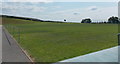
Trebanog Field, Trebanog
Set back from the east side of the A4233 Trebanog Road, Trebanog Field is the home ground of Trebanog FC (Football Club). Formed in 2013, the club play in the Rhondda District Football League.
The goalposts have been taken down for the off season (viewed in late July).
They will no doubt be re-erected in August for the start of the new season.
Image: © Jaggery
Taken: 30 Jul 2014
0.06 miles
7
Recently-built house on the site of a former church, Trebanog
The house on the left is on the Trebanog Road site previously occupied by
Mount Zion English Baptist Church, a "tin chapel" similar to this one http://www.geograph.org.uk/photo/4097700 nearby.
Image: © Jaggery
Taken: 30 Jul 2014
0.08 miles
8
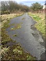
Remains of Old Road
The remains of the old road from Tonyrefail to Trebanog, now replaced by the A4233.
Image: © Alan Hughes
Taken: 9 Mar 2017
0.08 miles
9
Long grass strip in Trebanog
A narrow tongue of grass extends for 100 metres on the east side of the A4233 Trebanog Road.
Image: © Jaggery
Taken: 30 Jul 2014
0.08 miles
10
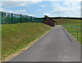
Path to the pavilion in Trebanog Field, Trebanog
Set back from the east side of the A4233 Trebanog Road, Trebanog Field is the home ground of Trebanog FC (Football Club). Formed in 2013, the club play in the Rhondda District Football League.
Image: © Jaggery
Taken: 30 Jul 2014
0.09 miles