IMAGES TAKEN NEAR TO
Beech Street, PORTH, CF39 8UD
Introduction
This page details the photographs taken nearby to Beech Street, CF39 8UD by members of the Geograph project.
The Geograph project started in 2005 with the aim of publishing, organising and preserving representative images for every square kilometre of Great Britain, Ireland and the Isle of Man.

There are currently over 7.5m images from over14,400 individuals and you can help contribute to the project by visiting https://www.geograph.org.uk
Image Map
Images are licensed for reuse under creativecommons.org/licenses/by-sa/2.0
Notes
- Clicking on the map will re-center to the selected point.
- The higher the marker number, the further away the image location is from the centre of the postcode.
Image Listing (40 Images Found)
Images are licensed for reuse under creativecommons.org/licenses/by-sa/2.0
Image
Details
Distance
1
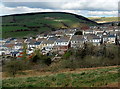
Garden Village, Gilfach Goch
A view of Garden Village taken from Lakeside Farm.
Image: © Wyndham Jones
Taken: 6 Feb 2009
0.05 miles
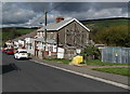
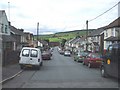
2
Oak Street, Hendreforgan, Gilfach Goch
Viewed across Thomas Street.
Image: © Jaggery
Taken: 11 Apr 2014
0.06 miles
3
View north from the end of Thomas St, Gilfach Garden Village, Gilfach Goch
The end houses of Llewellyn St and Holly St can be seen.
Image: © John Lord
Taken: 12 Sep 2008
0.06 miles
4
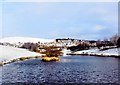
Course of dismantled railway, and Ogwr Fach below
Image: © Ruth Sharville
Taken: 23 Jun 2007
0.08 miles
5
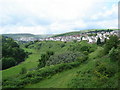
Valley houses, Gilfach Goch
A small part of Gilfach Goch viewed from the A4093 near the SW boundary of the village.
Wind turbines line a distant hilltop on the right.
Image: © Jaggery
Taken: 11 Apr 2014
0.09 miles
6
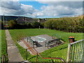
Three benches in a corner of a green, Gilfach Goch
Set below Cambrian Avenue, on the west side of this community centre. http://www.geograph.org.uk/photo/3933753
Image: © Jaggery
Taken: 11 Apr 2014
0.09 miles
7
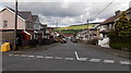
Wood Street, Hendreforgan, Gilfach Goch
Viewed from the Cambrian Avenue end. Wood Street is one of several parallel streets in this area ending on the east bank of the Ogwr Fach river (ahead).
Image: © Jaggery
Taken: 11 Apr 2014
0.09 miles
8
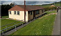
Cambrian Avenue Community Centre, Gilfach Goch
Set below the south side of Cambrian Road.
Image: © Jaggery
Taken: 11 Apr 2014
0.10 miles
9
Oak St, Gilfach Garden Village, Gilfach Goch
Taken from the junction with Thomas St.
Image: © John Lord
Taken: 12 Sep 2008
0.10 miles
10

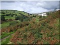
Path to a chapel building, Hendreforgan, Gilfach Goch
The building is accessed via a 25 metre long path from Cambrian Avenue.
There were no name signs here in April 2014, so it may be that Moriah Baptist Chapel has closed down.
Image: © Jaggery
Taken: 11 Apr 2014
0.11 miles