IMAGES TAKEN NEAR TO
Meadow Street, PORTH, CF39 8TA
Introduction
This page details the photographs taken nearby to Meadow Street, CF39 8TA by members of the Geograph project.
The Geograph project started in 2005 with the aim of publishing, organising and preserving representative images for every square kilometre of Great Britain, Ireland and the Isle of Man.

There are currently over 7.5m images from over14,400 individuals and you can help contribute to the project by visiting https://www.geograph.org.uk
Image Map
Images are licensed for reuse under creativecommons.org/licenses/by-sa/2.0
Notes
- Clicking on the map will re-center to the selected point.
- The higher the marker number, the further away the image location is from the centre of the postcode.
Image Listing (26 Images Found)
Images are licensed for reuse under creativecommons.org/licenses/by-sa/2.0
Image
Details
Distance
1
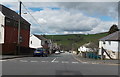
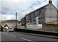
Meadow Street, Gilfach Goch
Viewed across Cambrian Avenue. This is the northernmost of several parallel streets ending on the east bank of the Ogwr Fach river (ahead).
Image: © Jaggery
Taken: 11 Apr 2014
0.03 miles
2
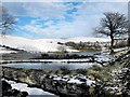
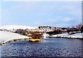
A view from Lakeside Farm
A view of Garden Village, Gilfach Goch and surrounding mountains.
Image: © Wyndham Jones
Taken: 6 Feb 2009
0.03 miles
3
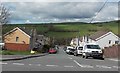
Elm Street, Gilfach Goch
Viewed across Cambrian Avenue.This is one of several parallel streets ending on the east bank of the Ogwr Fach river (ahead).
Image: © Jaggery
Taken: 11 Apr 2014
0.05 miles
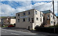
4
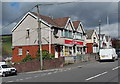
D & P Price, Gilfach Goch
Newsagents and general stores in Cambrian Avenue, on the corner of Elm Street.
Image: © Jaggery
Taken: 11 Apr 2014
0.05 miles
5
The Legion, Gilfach Goch
The Royal British Legion Club is at 17 Cambrian Avenue.
Image: © Jaggery
Taken: 11 Apr 2014
0.08 miles
6
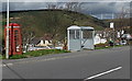
Phonebox, bus shelter and distant wind turbines, Gilfach Goch
Located alongside Cambrian Avenue near the corner of Wood Street, the metal bus shelter has replaced a corrugated-roofed concrete shelter. In the distance are a few of the many wind turbines on hilltops in this area.
Image: © Jaggery
Taken: 11 Apr 2014
0.08 miles
7
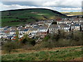
Valley houses, Gilfach Goch
A small part of Gilfach Goch viewed from the A4093 near the SW boundary of the village.
Wind turbines line a distant hilltop on the right.
Image: © Jaggery
Taken: 11 Apr 2014
0.09 miles
8
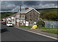
Wood Street, Hendreforgan, Gilfach Goch
Viewed from the Cambrian Avenue end. Wood Street is one of several parallel streets in this area ending on the east bank of the Ogwr Fach river (ahead).
Image: © Jaggery
Taken: 11 Apr 2014
0.09 miles
9
Gelli Arael Road houses, Gilfach Goch
Viewed across the B4564. The houses are near a disused quarry.
Image: © Jaggery
Taken: 11 Apr 2014
0.10 miles
10
Garden Village, Gilfach Goch
A view of Garden Village taken from Lakeside Farm.
Image: © Wyndham Jones
Taken: 6 Feb 2009
0.13 miles