1
The Britannic Club, Gilfach Goch
Image: © John Lord
Taken: 12 Sep 2008
0.01 miles
2
Etna Terrace, Gilfach Goch
Etna Terrace is a group of 8 semi-detached houses at the southern
end of High Street, near the Coronation Road junction.
Image: © Jaggery
Taken: 11 Apr 2014
0.01 miles
3
Two care vans parked in Etna Terrace, Gilfach Goch
Behind a Riverside Garage Auto Care van is a British Gas HomeCare van.
Image: © Jaggery
Taken: 11 Apr 2014
0.02 miles
4
The Britannic Club, Gilfach Goch
Club at 2-4 High Street, opposite the turning for the southern end of Glamorgan Terrace.
The text under the name is
Good Beer ● Wines ● Spirits
Function Room.
Image: © Jaggery
Taken: 11 Apr 2014
0.03 miles
5
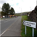
Evanstown this way, Gilfach Goch
The sign near the corner of High Street points along Coronation Road towards Evanstown.
Sŵn yr Afon http://www.geograph.org.uk/photo/3947609 is behind the trees.
Image: © Jaggery
Taken: 11 Apr 2014
0.04 miles
6
Gilfach Goch Community Council Offices
An old coalmine tram is in front
Image: © John Lord
Taken: 12 Sep 2008
0.04 miles
7
Junction in Gilfach Goch
Coronation Road on the left, High Street on the right. Both roads are the B4564, the route of which forms a loop ahead. The northern edge of the loop is about 1.4km (nearly a mile) away.
Image: © Jaggery
Taken: 11 Apr 2014
0.04 miles
8
Gilfach Goch Community Council offices and Miners Memorial
Located at the junction of High Street and Coronation Road. http://www.geograph.org.uk/photo/3947726 to a closer view of the memorial.
Image: © Jaggery
Taken: 11 Apr 2014
0.05 miles
9
Gilfach Goch Day Centre
Operated by Rhondda Cynon Taf council, located in High Street Gilfach Goch.
The council website states "anyone over the age of 50 can visit. It's where you can go to meet new people, bump into old friends or enjoy a new social activity ranging from old time dancing to craft classes and indoor bowls."
Image: © Jaggery
Taken: 11 Apr 2014
0.05 miles
10
Sŵn yr Afon, Gilfach Goch
Located on the west side of Coronation Road, Sŵn yr Afon is housing with support, managed by RCT Homes Ltd. Built in 1984, Sŵn yr Afon has 33 flats (1-bedroom or 2-bedroom), with a resident management staff and community alarm service.
Image: © Jaggery
Taken: 11 Apr 2014
0.05 miles


