IMAGES TAKEN NEAR TO
Mount Pleasant Road, PORTH, CF39 8SG
Introduction
This page details the photographs taken nearby to Mount Pleasant Road, CF39 8SG by members of the Geograph project.
The Geograph project started in 2005 with the aim of publishing, organising and preserving representative images for every square kilometre of Great Britain, Ireland and the Isle of Man.

There are currently over 7.5m images from over14,400 individuals and you can help contribute to the project by visiting https://www.geograph.org.uk
Image Map
Images are licensed for reuse under creativecommons.org/licenses/by-sa/2.0
Notes
- Clicking on the map will re-center to the selected point.
- The higher the marker number, the further away the image location is from the centre of the postcode.
Image Listing (44 Images Found)
Images are licensed for reuse under creativecommons.org/licenses/by-sa/2.0
Image
Details
Distance
1
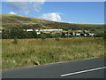
Cottages seen from B4564
The B4564 loops round on the left to pass the cottages opposite, and completes the circle at Gilfach Goch.
Image: © Colin Pyle
Taken: 22 Aug 2008
0.06 miles
2

This way to Fair View, Gilfach Goch
An arrow on the sign on the corner of High Street points towards Fair View,
where the houses are beyond a hairpin bend out of shot ahead.
Image: © Jaggery
Taken: 11 Apr 2014
0.06 miles
3

Wheelie bins, High Street, Gilfach Goch
In many parts of the UK, wheelie bins, here dark green, have replaced dustbins as receptacles for waste that cannot be recycled. Wheelie bins are usually emptied by council operatives either weekly or fortnightly, varying with location.
Image: © Jaggery
Taken: 11 Apr 2014
0.07 miles
4

Former Blandy Arms in Gilfach Goch
The former pub at 174 High Street looked to have been disused for several years in this April 2014 view.
Image: © Jaggery
Taken: 11 Apr 2014
0.07 miles
5
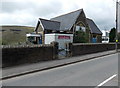
Former Gilfach Goch Community Centre
A notice on the door of the High Street building shows DANGEROUS STRUCTURE - KEEP OUT.
Image: © Jaggery
Taken: 11 Apr 2014
0.07 miles
6

Gilfach Goch Flying Start Centre
High Street care centre for preschool children in Gilfach Goch Old Infant School.
Image: © Jaggery
Taken: 11 Apr 2014
0.07 miles
7
Rear of the former Blandy Arms Hotel in Gilfach Goch
Image: © Gareth James
Taken: 2 Jan 2015
0.09 miles
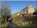
8

Long row of houses, High Street, Gilfach Goch
These houses on the east side of High Street are set several metres above road level.
Image: © Jaggery
Taken: 11 Apr 2014
0.09 miles
9

High Street houses, Gilfach Goch
Viewed across the B4564 High Street. The New Blandy Terrace junction is on the left.
Image: © Jaggery
Taken: 11 Apr 2014
0.09 miles
10

Contrasting High Street bus shelters in Gilfach Goch
Only the dark green shelter on the right appears in a Google Earth Street View taken in September 2009, so presumably the shelter on the left is the newer type of standard shelter in this area.
Image: © Jaggery
Taken: 11 Apr 2014
0.11 miles