IMAGES TAKEN NEAR TO
Parklands Road, PORTH, CF39 8PE
Introduction
This page details the photographs taken nearby to Parklands Road, CF39 8PE by members of the Geograph project.
The Geograph project started in 2005 with the aim of publishing, organising and preserving representative images for every square kilometre of Great Britain, Ireland and the Isle of Man.

There are currently over 7.5m images from over14,400 individuals and you can help contribute to the project by visiting https://www.geograph.org.uk
Image Map
Images are licensed for reuse under creativecommons.org/licenses/by-sa/2.0
Notes
- Clicking on the map will re-center to the selected point.
- The higher the marker number, the further away the image location is from the centre of the postcode.
Image Listing (67 Images Found)
Images are licensed for reuse under creativecommons.org/licenses/by-sa/2.0
Image
Details
Distance
1
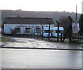
Tonyrefail Auto Services
Set back 35 metres from the south side of High Street Tonyrefail.
Image: © Jaggery
Taken: 10 Jan 2018
0.07 miles
2
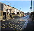
High Street bus stop, Tonyrefail
This stop for southbound buses is opposite St David's Church. https://www.geograph.org.uk/photo/5649702
Image: © Jaggery
Taken: 10 Jan 2018
0.07 miles
3
Western Power Distribution electricity substation, High Street, Tonyrefail
In a locked enclosure above Tonyrefail Auto Services. https://www.geograph.org.uk/photo/5649394
Image: © Jaggery
Taken: 10 Jan 2018
0.08 miles
5
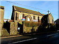
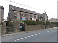
Edwardian St David's Church, High Street, Tonyrefail
In the Church in Wales Parish of Tonyrefail, Diocese of Llandaff.
The church was built in 1902-1903 in the Early English style.
Image: © Jaggery
Taken: 10 Jan 2018
0.09 miles
6
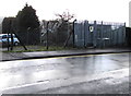
The Co-operative Funeralcare, High Street, Tonyrefail
Opposite the St John's Road junction.
Image: © Jaggery
Taken: 10 Jan 2018
0.10 miles
7
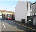
One-way side road on the west side of St John's Road, Tonyrefail
From St John's Road to School Street.
Image: © Jaggery
Taken: 10 Jan 2018
0.10 miles
8
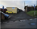
Two telecoms cabinets near the corner of Prichard Street, Tonyrefail
Alongside a side street below Prichard Street viewed in January 2018.
There were no cabinets here in a June 2011 Google Earth Street View.
Image: © Jaggery
Taken: 10 Jan 2018
0.10 miles
9
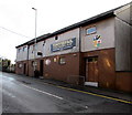
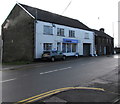
Tonyrefail RFC clubhouse, High Street, Tonyrefail
The large name sign shows that Tonyrefail Rugby Football Club was established in 1893.
The depiction of an anvil on the club's badge refers to the literal meaning
of the Welsh Tonyrefail - smithy or forge on a grassy plot of land.
Image: © Jaggery
Taken: 10 Jan 2018
0.10 miles
10
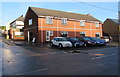
B & F Cars premises in High Street, Tonyrefail
Located in the Old Mazda Garage on the corner of St John's Road.
Image: © Jaggery
Taken: 10 Jan 2018
0.11 miles