1
Edwardian St David's Church, High Street, Tonyrefail
In the Church in Wales Parish of Tonyrefail, Diocese of Llandaff.
The church was built in 1902-1903 in the Early English style.
Image: © Jaggery
Taken: 10 Jan 2018
0.05 miles
2
St David's Church, Tonyrefail
Image: © John Lord
Taken: 1 Nov 2017
0.05 miles
3
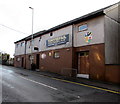
Tonyrefail RFC clubhouse, High Street, Tonyrefail
The large name sign shows that Tonyrefail Rugby Football Club was established in 1893.
The depiction of an anvil on the club's badge refers to the literal meaning
of the Welsh Tonyrefail - smithy or forge on a grassy plot of land.
Image: © Jaggery
Taken: 10 Jan 2018
0.06 miles
4
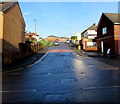
Side road from Prichard Street to High Street, Tonyrefail
Extending for about 90 metres.
Image: © Jaggery
Taken: 10 Jan 2018
0.07 miles
5
Ordnance Survey Cut Mark
This OS cut mark can be found on No54 High Street. It marks a point 147.365m above mean sea level.
Image: © Adrian Dust
Taken: 27 May 2018
0.07 miles
6
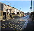
High Street bus stop, Tonyrefail
This stop for southbound buses is opposite St David's Church. https://www.geograph.org.uk/photo/5649702
Image: © Jaggery
Taken: 10 Jan 2018
0.07 miles
7
One-way side road on the west side of St John's Road, Tonyrefail
From St John's Road to School Street.
Image: © Jaggery
Taken: 10 Jan 2018
0.07 miles
8
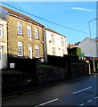
Victorian cottage in High Street, Tonyrefail
The tablet on the house with five windows shows Maesteg Cottage 1883.
Image: © Jaggery
Taken: 10 Jan 2018
0.08 miles
9
St John's Road, Tonyrefail
Ascending from the north side of High Street. The 30mph speed limit drops to 20 on the approach to a school.
Image: © Jaggery
Taken: 10 Jan 2018
0.09 miles
10
Western Power Distribution electricity substation, High Street, Tonyrefail
In a locked enclosure above Tonyrefail Auto Services. https://www.geograph.org.uk/photo/5649394
Image: © Jaggery
Taken: 10 Jan 2018
0.10 miles


