IMAGES TAKEN NEAR TO
Thomastown, Tonyrefail, PORTH, CF39 8DJ
Introduction
This page details the photographs taken nearby to CF39 8DJ by members of the Geograph project.
The Geograph project started in 2005 with the aim of publishing, organising and preserving representative images for every square kilometre of Great Britain, Ireland and the Isle of Man.

There are currently over 7.5m images from over14,400 individuals and you can help contribute to the project by visiting https://www.geograph.org.uk
Image Map
Images are licensed for reuse under creativecommons.org/licenses/by-sa/2.0
Notes
- Clicking on the map will re-center to the selected point.
- The higher the marker number, the further away the image location is from the centre of the postcode.
Image Listing (7 Images Found)
Images are licensed for reuse under creativecommons.org/licenses/by-sa/2.0
Image
Details
Distance
1
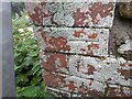
Ordnance Survey Cut Mark
This OS cut mark can be found on the farm building NW side of the track. It marks a point 207.715m above mean sea level.
Image: © Adrian Dust
Taken: 17 May 2022
0.10 miles
2
Gelli?r haidd uchaf
Half-hearted attempts appear to have been made to rebuild this ruined farmhouse. Work in progress!
See also Image
Note that the front elevation of the farmhouse is in one grid square and the rear is in another.
Image: © Alan Hughes
Taken: 6 Feb 2019
0.22 miles
3
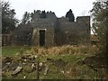
Gelli?r haidd uchaf
Some work has been carried out to restore the old farmhouse of Gelli’r haidd uchaf.
See also Image
See also Image
Note that the front elevation of the farmhouse is in one grid square and the rear is in another.
Image: © Alan Hughes
Taken: 6 Feb 2019
0.22 miles
4
Gelli'r-haidd-uchaf under restoration
This old ruined farmhouse is now being saved
Image: © John Finch
Taken: 15 Oct 2011
0.23 miles
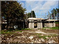
5
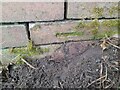
Ordnance Survey Cut Mark
This OS cut mark can be found on the brick wall west side of the track. It marks a point 189.467m above mean sea level.
Image: © Adrian Dust
Taken: 17 May 2022
0.24 miles
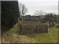
6
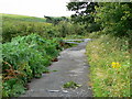
The end of the road
The end of the public road out of Thomastown that follows a steep-sided, wooded river valley on the left. Fields given over to sheep grazing on the other side of the valley can just be seen in the top left of the picture.
Image: © Alan Burke
Taken: 10 Aug 2008
0.24 miles
7
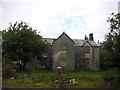
Gelli'r-haidd-uchaf
The old ruined farmhouse
Image: © John Finch
Taken: 23 Aug 2008
0.25 miles