IMAGES TAKEN NEAR TO
Tonyrefail, PORTH, CF39 8BW
Introduction
This page details the photographs taken nearby to CF39 8BW by members of the Geograph project.
The Geograph project started in 2005 with the aim of publishing, organising and preserving representative images for every square kilometre of Great Britain, Ireland and the Isle of Man.

There are currently over 7.5m images from over14,400 individuals and you can help contribute to the project by visiting https://www.geograph.org.uk
Image Map
Images are licensed for reuse under creativecommons.org/licenses/by-sa/2.0
Notes
- Clicking on the map will re-center to the selected point.
- The higher the marker number, the further away the image location is from the centre of the postcode.
Image Listing (49 Images Found)
Images are licensed for reuse under creativecommons.org/licenses/by-sa/2.0
Image
Details
Distance
2
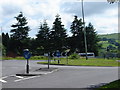
Small Roundabout, near bigger one
Lack of place names in this area - so you'll just need to look at the map!
Image: © Ruth Sharville
Taken: 23 Jun 2007
0.06 miles
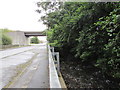
4
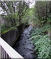
Ely River, Tonyrefail
Flowing towards the camera on the Tynybryn Road bridge.
Image: © Jaggery
Taken: 24 Aug 2017
0.11 miles
5
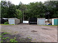
Riverbank lockup garages, Tonyrefail
On a bank of the Ely River, viewed from Tynybryn Road.
Image: © Jaggery
Taken: 24 Aug 2017
0.12 miles
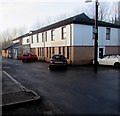
7
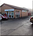
Well Pharmacy, Park Lane, Tonyrefail
Located opposite Park Lane Medical Centre. https://www.geograph.org.uk/photo/5648636
Image: © Jaggery
Taken: 10 Jan 2018
0.13 miles
8
Ely River, Thomastown
Here flowing below the east side of Francis Street in the north of Thomastown.
The A4093 overbridge http://www.geograph.org.uk/photo/5509581 is in the background.
Image: © Jaggery
Taken: 24 Aug 2017
0.13 miles
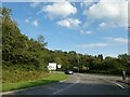
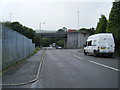
9
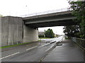
South side of the A4093 overbridge, Thomastown
This bridge is where Francis Street Thomastown on this side becomes Tynybryn Road Tonyrefail on the other side. The railings on the right are above the Ely River.
Image: © Jaggery
Taken: 24 Aug 2017
0.13 miles
10
Park Lane Medical Centre, Tonyrefail
Located below Mill Street, opposite a Well pharmacy. https://www.geograph.org.uk/photo/5648641
Image: © Jaggery
Taken: 10 Jan 2018
0.13 miles