IMAGES TAKEN NEAR TO
PORTH, CF39 0LR
Introduction
This page details the photographs taken nearby to CF39 0LR by members of the Geograph project.
The Geograph project started in 2005 with the aim of publishing, organising and preserving representative images for every square kilometre of Great Britain, Ireland and the Isle of Man.

There are currently over 7.5m images from over14,400 individuals and you can help contribute to the project by visiting https://www.geograph.org.uk
Image Map
Images are licensed for reuse under creativecommons.org/licenses/by-sa/2.0
Notes
- Clicking on the map will re-center to the selected point.
- The higher the marker number, the further away the image location is from the centre of the postcode.
Image Listing (41 Images Found)
Images are licensed for reuse under creativecommons.org/licenses/by-sa/2.0
Image
Details
Distance
1
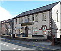
Ynyshir & District Workingmens Club
The club is located between numbers 100 and 101 Aberrhondda Road.
There is no apostrophe before the s in Workingmens on the club's name sign,
which shows that the function hall is available for private functions.
Image: © Jaggery
Taken: 19 Sep 2012
0.05 miles
3
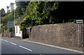
Northern boundary of Porth
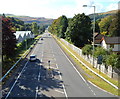
The road south from Ynyshir passes the boundary sign for Porth, a town in the county borough of Rhondda Cynon Taf. Porth's population on the day of the 2001 Census was 5,944.
Image: © Jaggery
Taken: 19 Sep 2012
0.07 miles
4
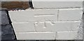
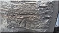
Ordnance Survey Cut Mark
This OS cut mark can be found on No30 Turberville Road. It marks a point 143.256m above mean sea level.
Image: © Adrian Dust
Taken: 24 Jun 2017
0.07 miles
5
A4233 south of a long footbridge, Ynyshir
Viewed from this http://www.geograph.org.uk/photo/3139911 footbridge.
The route of the A4233 here was formerly a railway line.
Faintly visible in the distance is the Rheola Bridge. http://www.geograph.org.uk/photo/2612363
Image: © Jaggery
Taken: 19 Sep 2012
0.08 miles
6
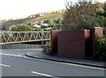
Basic urinal, Ynyshir
Located on the corner of Aberrhondda Road and Llanwonno Road, near a long footbridge. http://www.geograph.org.uk/photo/3139906
The small structure is a basic urinal (no pedestals or wash basins). Though such facilities have largely disappeared from many parts of South Wales, basic urinals (of varying designs) remain a common sight in the Rhondda.
Image: © Jaggery
Taken: 19 Sep 2012
0.09 miles
7
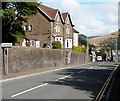
Southern boundary of Ynyshir
Aberrhondda Road from Porth reaches the Rhondda Cynon Taf village of Ynyshir.
Its population on the day of the 2001 Census was 3,442.
Image: © Jaggery
Taken: 19 Sep 2012
0.10 miles
8

Ynyshir and Porth from Troed-y-rhiw mountain
Looking south-southeast
Image: © David Spencer
Taken: 23 Jul 2005
0.12 miles
9
Ordnance Survey Cut Mark
This OS cut mark can be found on the Vets, No56 Aber Rhondda Road. It marks a point 109.067m above mean sea level.
Image: © Adrian Dust
Taken: 4 Jun 2017
0.13 miles
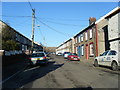
10
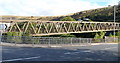
Western end of a long footbridge, Ynyshir
Viewed from Aberrhondda Road. The footbridge extends for about 120 metres, across the Rhondda Fach river and the A4233. The other end is near Ynyshir Community Primary School http://www.geograph.org.uk/photo/3139596 in Llanwonno Road.
Image: © Jaggery
Taken: 19 Sep 2012
0.13 miles