IMAGES TAKEN NEAR TO
Park View, PORTH, CF39 0LB
Introduction
This page details the photographs taken nearby to Park View, CF39 0LB by members of the Geograph project.
The Geograph project started in 2005 with the aim of publishing, organising and preserving representative images for every square kilometre of Great Britain, Ireland and the Isle of Man.

There are currently over 7.5m images from over14,400 individuals and you can help contribute to the project by visiting https://www.geograph.org.uk
Image Map
Images are licensed for reuse under creativecommons.org/licenses/by-sa/2.0
Notes
- Clicking on the map will re-center to the selected point.
- The higher the marker number, the further away the image location is from the centre of the postcode.
Image Listing (22 Images Found)
Images are licensed for reuse under creativecommons.org/licenses/by-sa/2.0
Image
Details
Distance
1
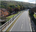
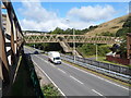
Ynyshir : A4233 heads SE towards Porth
Viewed from a footbridge. Built in 2005, the A4233 is the Porth and Lower Rhondda Fach Relief Road (Porth Bypass), which follows the route of the dismantled Rhondda Fach branch railway line.
Image: © Jaggery
Taken: 19 Sep 2012
0.03 miles
2
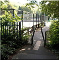
Rhondda Fach Trail passes tennis courts, Wattstown
On the east bank of the Rhondda Fach river.
Image: © Jaggery
Taken: 19 Sep 2012
0.04 miles
3
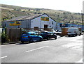
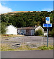
Tonypandy Autos, Ynyshir
Vehicle repairs and servicing business in Ynyshir Road.
Image: © Jaggery
Taken: 19 Sep 2012
0.04 miles
4
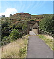
Ynyshir Road side of an extensive footbridge, Ynyshir
The footbridge crosses the A4233.
Image: © Jaggery
Taken: 19 Sep 2012
0.06 miles
5
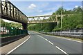
Footbridge over the A4233, Ynyshir
Viewed from the Ynyshir Road side. Built in 2005, the A4233 is the Porth and Lower Rhondda Fach Relief Road (Porth Bypass), which follows the route of the dismantled Rhondda Fach branch railway line.
Image: © Jaggery
Taken: 19 Sep 2012
0.08 miles
6
NE side of a footbridge over the A4233, Ynyshir
Viewed from the Rhondda Fach Trail looking across the A4233 towards Ynyshir Road.
Built in 2005, the A4233 is the Porth and Lower Rhondda Fach Relief Road (Porth Bypass),
which follows the route of a dismantled railway line.
Image: © Jaggery
Taken: 19 Sep 2012
0.09 miles
7
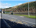
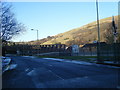
Girder bridge
Bridge over the A4233 between Ynyshir and Wattstown.
Image: © Alan Hughes
Taken: 23 May 2019
0.09 miles
9
Rhondda Fach Trail and Lower Bailey Street, Wattstown
One sign arm alongside the Rhondda Fach Trail points left towards Maerdy, Tylorstown and Wattstown (west). The arm pointing right shows Porth, Ynyshir and Wattstown (east).
Lower Bailey Street Wattstown is in the background
Image: © Jaggery
Taken: 19 Sep 2012
0.10 miles
10
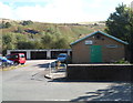
Ynyshir Meal Production Kitchen
Viewed from Ynyshir Road, the building is used by Ynyshir Community Meals on Wheels service.
Image: © Jaggery
Taken: 19 Sep 2012
0.12 miles