IMAGES TAKEN NEAR TO
Thomas Place, PORTH, CF39 0EP
Introduction
This page details the photographs taken nearby to Thomas Place, CF39 0EP by members of the Geograph project.
The Geograph project started in 2005 with the aim of publishing, organising and preserving representative images for every square kilometre of Great Britain, Ireland and the Isle of Man.

There are currently over 7.5m images from over14,400 individuals and you can help contribute to the project by visiting https://www.geograph.org.uk
Image Map
Images are licensed for reuse under creativecommons.org/licenses/by-sa/2.0
Notes
- Clicking on the map will re-center to the selected point.
- The higher the marker number, the further away the image location is from the centre of the postcode.
Image Listing (36 Images Found)
Images are licensed for reuse under creativecommons.org/licenses/by-sa/2.0
Image
Details
Distance
2

A4233 north of Station Road bridge, Ynyshir
Viewed from this http://www.geograph.org.uk/photo/3140061 bridge. The site of Ynyshir railway station was directly ahead, just beyond the bridge. The station closed in 1964 on the cessation of passenger services. The line remained open for coal traffic until 1986. The A4233 uses the trackbed of the dismantled railway lines.
Image: © Jaggery
Taken: 19 Sep 2012
0.02 miles
3
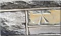
Ordnance Survey Cut Mark
This OS cut mark can be found on No65 Ynyshir Road. It marks a point 124.953m above mean sea level.
Image: © Adrian Dust
Taken: 24 Jun 2017
0.04 miles
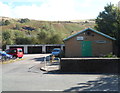
4
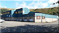
DS Smith Packaging, Ynyshir
Viewed from Ynyshir Road in the north of Ynyshir.
Image: © Jaggery
Taken: 19 Sep 2012
0.07 miles
5

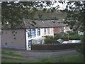
Weston Terrace, Ynyshir
Weston Terrace is aligned south-north along the western edge of the A4233,
the route of which here was formerly a railway.
Image: © Jaggery
Taken: 19 Sep 2012
0.07 miles
6

Ordnance Survey Cut Mark
This OS cut mark can be found on No22 Standard View. It marks a point 120.091m above mean sea level.
Image: © Adrian Dust
Taken: 24 Jun 2017
0.09 miles
7
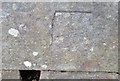
Ordnance Survey Cut Mark
This badly damaged OS cut mark can be found on the wall west side of Ynyshir Road. It marks a point 127.858m above mean sea level.
Image: © Adrian Dust
Taken: 24 Jun 2017
0.10 miles
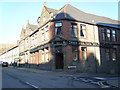
9
The Station Hotel, Ynyshir
On the corner of Station Road and Ynyshir Road. Ynyshir railway station,
which closed in 1964, was formerly located less than 100 metres away.
Image: © Jaggery
Taken: 19 Sep 2012
0.11 miles
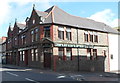
10
Ynyshir Meal Production Kitchen
Viewed from Ynyshir Road, the building is used by Ynyshir Community Meals on Wheels service.
Image: © Jaggery
Taken: 19 Sep 2012
0.11 miles