1
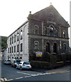
Ynyshir : Moriah Calvinistic Methodist Chapel viewed from the NW
View across Ynyshir Road and Wind Street. The year 1909 is inscribed in stone above
the central first floor window. A notice outside the chapel shows BOYS & YOUTH CLUB.
Image: © Jaggery
Taken: 19 Sep 2012
0.03 miles
2
Ynyshir : Moriah Calvinistic Methodist Chapel viewed from the SW
The chapel is on the corner of Ynyshir Road and Wind Street.
The year 1909 is inscribed in stone above the central first floor window.
A notice outside the chapel shows BOYS & YOUTH CLUB.
Image: © Jaggery
Taken: 19 Sep 2012
0.03 miles
3
A4233 north of a long footbridge, Ynyshir
Viewed from this http://www.geograph.org.uk/photo/3139911 footbridge.
The route of the A4233 here was formerly a railway line.
Image: © Jaggery
Taken: 19 Sep 2012
0.04 miles
4
Ynyshir Road houses, Ynyshir
A long row of houses on the west side of Ynyshir Road, viewed from the corner of James Terrace. http://www.geograph.org.uk/photo/3139945
Image: © Jaggery
Taken: 19 Sep 2012
0.04 miles
5
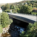
A4233 crosses the Rhondda Fach, Ynyshir
Viewed from this footbridge http://www.geograph.org.uk/photo/3139911 which crosses both the river and the road.
Image: © Jaggery
Taken: 19 Sep 2012
0.04 miles
6
James Terrace, Ynyshir
Viewed from the Ynyshir Road end. The houses are all on the north side of the street.
James Terrace ends at a wall near the edge of the A4233 and a river, the Rhondda Fach.
Image: © Jaggery
Taken: 19 Sep 2012
0.04 miles
7
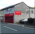
Reds, Ynyshir
Plumbing and electrical warehouse at 128 Ynyshir Road.
Image: © Jaggery
Taken: 19 Sep 2012
0.05 miles
8
Western end of a long footbridge, Ynyshir
Viewed from Aberrhondda Road. The footbridge extends for about 120 metres, across the Rhondda Fach river and the A4233. The other end is near Ynyshir Community Primary School http://www.geograph.org.uk/photo/3139596 in Llanwonno Road.
Image: © Jaggery
Taken: 19 Sep 2012
0.06 miles
9
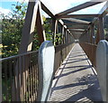
Across a long footbridge, Ynyshir
A view from the western side of this http://www.geograph.org.uk/photo/3139906 footbridge.
The metal barriers prevent access for anything wider than a 2-wheeled vehicle.
Image: © Jaggery
Taken: 19 Sep 2012
0.06 miles
10
Ordnance Survey Cut Mark
This OS cut mark can be found on No19 Ynyshir Road. It marks a point 113.154m above mean sea level.
Image: © Adrian Dust
Taken: 24 Jun 2017
0.06 miles


