
IMAGES TAKEN NEAR TO
Pleasant View, PONTYPRIDD, CF38 2DT
Introduction
This page details the photographs taken nearby to Pleasant View, CF38 2DT by members of the Geograph project.
The Geograph project started in 2005 with the aim of publishing, organising and preserving representative images for every square kilometre of Great Britain, Ireland and the Isle of Man.

There are currently over 7.5m images from over14,400 individuals and you can help contribute to the project by visiting https://www.geograph.org.uk
Image Map
Images are licensed for reuse under creativecommons.org/licenses/by-sa/2.0
Notes
- Clicking on the map will re-center to the selected point.
- The higher the marker number, the further away the image location is from the centre of the postcode.
Image Listing (62 Images Found)
Images are licensed for reuse under creativecommons.org/licenses/by-sa/2.0
Image
Details
Distance
1
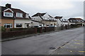
Garth View, Beddau
Viewed from the corner of the B4595 Tynant Road.
Image: © Jaggery
Taken: 7 Apr 2018
0.05 miles
2
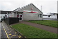
Beddau Post Office
Set back from the south side of Tynant Road near the Beddau/Tynant boundary.
Image: © Jaggery
Taken: 7 Apr 2018
0.07 miles
3
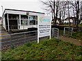
Beddau and Tynant Community Library, Beddau
Set back from the south side of Tynant Road in Beddau a few metres from the Tynant boundary sign.
In March 2018 the nameboard shows that the library is run by volunteers for the local community.
The library was formerly part of the Rhondda Cynon Taf County Borough library service.
Image: © Jaggery
Taken: 30 Mar 2018
0.07 miles
4
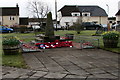
Beddau and Tynant War Memorial, Beddau
Located in Beddau Memorial Garden between the B4595 Tynant Road and Garth View (ahead).
The War Memorial was dedicated in May 1966.
Image: © Jaggery
Taken: 30 Mar 2018
0.07 miles
5
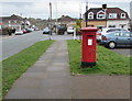
Queen Elizabeth II pillarbox, Tynant Road, Tynant
Located a few metres from Beddau Post Office https://www.geograph.org.uk/photo/5730822 near the Beddau boundary.
Image: © Jaggery
Taken: 7 Apr 2018
0.08 miles
6
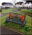
Sara Head bench in Beddau Memorial Garden, Beddau
Sara Head is a Welsh Paralympic table tennis player who was born in Cardiff in 1980. She grew up here in Beddau and was educated at Bryn Celynnog Comprehensive School in the village. She was selected for Great Britain for the 2012 Paralympic Games in London where she won the bronze medal in the women's team table tennis class 1–3 event with team mate Jane Campbell.
Image: © Jaggery
Taken: 30 Mar 2018
0.08 miles
7
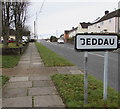
Beddau boundary sign
The sign alongside the B4595 Tynant Road faces Tynant.
The Tynant boundary sign https://www.geograph.org.uk/photo/5721499 is on the back of this one.
Image: © Jaggery
Taken: 30 Mar 2018
0.08 miles
8
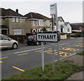
Tynant boundary sign
The sign alongside the B4595 Tynant Road faces Beddau.
The Beddau boundary sign https://www.geograph.org.uk/photo/5721504 is on the back of this one.
Image: © Jaggery
Taken: 30 Mar 2018
0.08 miles
9
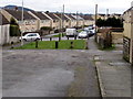
Towards Moorland Crescent, Tynant
Viewed from the side road from the B4595 Parish Road. Concrete posts block the passage of motor vehicles.
Image: © Jaggery
Taken: 7 Apr 2018
0.09 miles
10
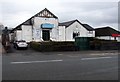
Cwm & Llantwit Welfare Hall, Tynant
Viewed across the B4595. The Coflein website records that Cwm & Llantwit Welfare Hall was officially opened on October 21st 1933. The building contained a public hall (capacity 450), billiards hall, reading room and library. A smaller hall was unveiled in 1949. Extensions to the main hall in 1956 raised its capacity to 516. Difficulties in maintaining the hall as a going concern were ended with the arrival of a cinema - the Welfare Hall was renamed the Gaiety Cinema. The cinema closed in June 1964 at which time the former name was revived. Other activities hosted were boxing matches and dancing sessions. The hall remains in use as a social club.
Image: © Jaggery
Taken: 7 Apr 2018
0.10 miles