IMAGES TAKEN NEAR TO
Parish Road, PONTYPRIDD, CF38 2BU
Introduction
This page details the photographs taken nearby to Parish Road, CF38 2BU by members of the Geograph project.
The Geograph project started in 2005 with the aim of publishing, organising and preserving representative images for every square kilometre of Great Britain, Ireland and the Isle of Man.

There are currently over 7.5m images from over14,400 individuals and you can help contribute to the project by visiting https://www.geograph.org.uk
Image Map
Images are licensed for reuse under creativecommons.org/licenses/by-sa/2.0
Notes
- Clicking on the map will re-center to the selected point.
- The higher the marker number, the further away the image location is from the centre of the postcode.
Image Listing (75 Images Found)
Images are licensed for reuse under creativecommons.org/licenses/by-sa/2.0
Image
Details
Distance
1
Dark blue house with a yellow front door, Tynant
Viewed across the B4595 Parish Road.
Image: © Jaggery
Taken: 7 Apr 2018
0.01 miles
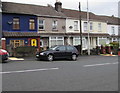
2
Blooms Boutique, Tynant
Florist at 82 Parish Road on the corner of Brynhyfryd. New Dimensionz hairdresser is next door.
Image: © Jaggery
Taken: 7 Apr 2018
0.02 miles
3
Amber's Cafe, Beddau
Viewed across Brynhyfryd on the approach to Parish Road.
Image: © Jaggery
Taken: 7 Apr 2018
0.02 miles
4
From 30 to 20 on Brynhyfryd, Tynant
The 30mph speed limit on the B4595 drops to 20mph along Brynhyfryd. Blooms Boutique https://www.geograph.org.uk/photo/5729678 is on the right.
Image: © Jaggery
Taken: 7 Apr 2018
0.02 miles
5

1st Beddau Scout Group hall, Brynhyfryd, Beddau
Image: © Jaggery
Taken: 7 Apr 2018
0.04 miles
6

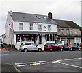
Ladbrokes, Tynant
Betting shop set back from the north side of the B4595 Tynant Road.
Image: © Jaggery
Taken: 7 Apr 2018
0.04 miles
7
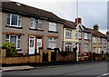
Parish Road houses, Tynant
Houses alongside the B4595 Parish Road NE of the Mildred Close junction.
Image: © Jaggery
Taken: 7 Apr 2018
0.04 miles
8
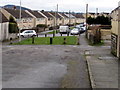
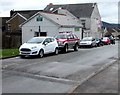
Towards Moorland Crescent, Tynant
Viewed from the side road from the B4595 Parish Road. Concrete posts block the passage of motor vehicles.
Image: © Jaggery
Taken: 7 Apr 2018
0.06 miles
9
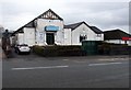
Cwm & Llantwit Welfare Hall, Tynant
Viewed across the B4595. The Coflein website records that Cwm & Llantwit Welfare Hall was officially opened on October 21st 1933. The building contained a public hall (capacity 450), billiards hall, reading room and library. A smaller hall was unveiled in 1949. Extensions to the main hall in 1956 raised its capacity to 516. Difficulties in maintaining the hall as a going concern were ended with the arrival of a cinema - the Welfare Hall was renamed the Gaiety Cinema. The cinema closed in June 1964 at which time the former name was revived. Other activities hosted were boxing matches and dancing sessions. The hall remains in use as a social club.
Image: © Jaggery
Taken: 7 Apr 2018
0.06 miles
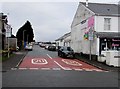
10
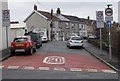
Mildred Street, Tynant
The 30mph speed limit on the B4595 Parish Road drops to 20mph along Mildred Street.
Image: © Jaggery
Taken: 7 Apr 2018
0.07 miles