IMAGES TAKEN NEAR TO
Gwaunmiskin Road, PONTYPRIDD, CF38 2AY
Introduction
This page details the photographs taken nearby to Gwaunmiskin Road, CF38 2AY by members of the Geograph project.
The Geograph project started in 2005 with the aim of publishing, organising and preserving representative images for every square kilometre of Great Britain, Ireland and the Isle of Man.

There are currently over 7.5m images from over14,400 individuals and you can help contribute to the project by visiting https://www.geograph.org.uk
Image Map
Images are licensed for reuse under creativecommons.org/licenses/by-sa/2.0
Notes
- Clicking on the map will re-center to the selected point.
- The higher the marker number, the further away the image location is from the centre of the postcode.
Image Listing (59 Images Found)
Images are licensed for reuse under creativecommons.org/licenses/by-sa/2.0
Image
Details
Distance
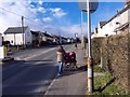
1
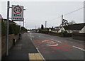
Start of the 20 zone, Common Approach, Beddau
The 30mph speed limit on Common Approach drops to 20mph near a speed bump.
Pointing this way, a nearby sign https://www.geograph.org.uk/photo/5722400 shows half a mile to Gwaunmiskin, 3 miles to Talbot Green.
Viewed from the corner of Tynant Road.
Image: © Jaggery
Taken: 30 Mar 2018
0.03 miles
2
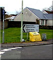
Yellow grit/salt box on a Beddau corner
On the corner of Llwyncrwn Road and Common Approach, half a mile from Gwaunmiskin,
3 miles from Talbot Green. The Welsh names of the two locations are also shown.
Image: © Jaggery
Taken: 30 Mar 2018
0.04 miles
3
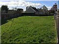
Not Quite a Village Green
A green space, but not quite a village green, at the edge of housing on Llwyncrwn Road in Beddau.
Image: © Alan Hughes
Taken: 9 Mar 2017
0.05 miles
4
Signs at the eastern end of Llwyncrwn Road, Beddau
No motor vehicles except for access and No Through Road. Llwyncrwn Road is not
a through route because of this https://www.geograph.org.uk/photo/5722099 metal barrier across the road 150 metres ahead.
Image: © Jaggery
Taken: 30 Mar 2018
0.05 miles
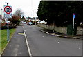
5
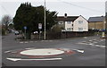
Mini-roundabout at crossroads in Beddau
Llwyncrwn Road is on the left and the B4595 Gwaunmiskin Road on the right,
where a direction sign shows Penycoedcae 2¾ (miles), Tonyrefail 3.
Image: © Jaggery
Taken: 30 Mar 2018
0.05 miles
6
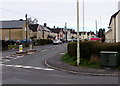
Virgin Media cabinet alongside the B4595 in Beddau
The dark green telecoms cabinet is on the corner of Tynant Road and Gwaunmiskin Road.
Image: © Jaggery
Taken: 30 Mar 2018
0.05 miles
8
Gwaunmiskin Road, Beddau
Looking to the NNW along the B4595 Gwaunmiskin Road from the corner of Llwyncrwn Road.
Image: © Jaggery
Taken: 30 Mar 2018
0.07 miles
9
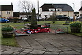
Beddau and Tynant War Memorial, Beddau
Located in Beddau Memorial Garden between the B4595 Tynant Road and Garth View (ahead).
The War Memorial was dedicated in May 1966.
Image: © Jaggery
Taken: 30 Mar 2018
0.07 miles
10
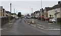
Gwaunmiskin Road
This is a long road passing through the heart of Beddau.
Image: © Derek Cummings
Taken: 10 Feb 2010
0.07 miles