IMAGES TAKEN NEAR TO
Church Road, PONTYPRIDD, CF38 1EX
Introduction
This page details the photographs taken nearby to Church Road, CF38 1EX by members of the Geograph project.
The Geograph project started in 2005 with the aim of publishing, organising and preserving representative images for every square kilometre of Great Britain, Ireland and the Isle of Man.

There are currently over 7.5m images from over14,400 individuals and you can help contribute to the project by visiting https://www.geograph.org.uk
Image Map
Images are licensed for reuse under creativecommons.org/licenses/by-sa/2.0
Notes
- Clicking on the map will re-center to the selected point.
- The higher the marker number, the further away the image location is from the centre of the postcode.
Image Listing (13 Images Found)
Images are licensed for reuse under creativecommons.org/licenses/by-sa/2.0
Image
Details
Distance
1
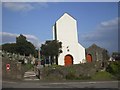
St Illtud's Church, Upper Church Village
The small square above the door is a stone inscribed "This steeple was made AM DOM (sic. presumably an error for AN[NO] DOM[INI]) Thomas Robt" together with other, apparently "unofficial", inscriptions.
Image: © John Lord
Taken: 19 Sep 2008
0.19 miles
3
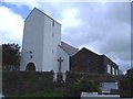
St Illtud Church, Upper Church Village
St Illtud Parish Church is on a site that has been used for worship since the fifth century although the present building only dates from the sixteenth century. The tower dates from 1636; the register from 1632, whilst the bell was cast during the nineteenth century. It was restored and rededicated in 1974.
Image: © Roger Cornfoot
Taken: 25 Apr 2007
0.20 miles
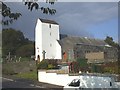
5
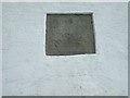
Stone on tower of St Illtud's Church, Upper Church Village
Image: © John Lord
Taken: 19 Sep 2008
0.20 miles
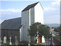
7
St Illtud's Church
View of church main entrance.
Image: © Stuart Lang
Taken: 8 Jun 2019
0.21 miles
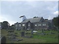
8
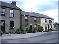
The Farmer's Arms, Upper Church Village
Image: © Roger Cornfoot
Taken: 25 Apr 2007
0.22 miles
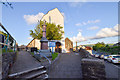
9
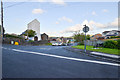
Upper Church Village
St Illtuds Church Junction, Upper Church Village.
Image: © Stuart Lang
Taken: 8 Jun 2019
0.22 miles
10
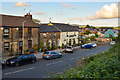
The Farmers Arms
The Farmers Arms Pub, Upper Church Village.
Image: © Stuart Lang
Taken: 8 Jun 2019
0.23 miles