IMAGES TAKEN NEAR TO
Treforest Industrial Estate, PONTYPRIDD, CF37 5TF
Introduction
This page details the photographs taken nearby to CF37 5TF by members of the Geograph project.
The Geograph project started in 2005 with the aim of publishing, organising and preserving representative images for every square kilometre of Great Britain, Ireland and the Isle of Man.

There are currently over 7.5m images from over14,400 individuals and you can help contribute to the project by visiting https://www.geograph.org.uk
Image Map
Images are licensed for reuse under creativecommons.org/licenses/by-sa/2.0
Notes
- Clicking on the map will re-center to the selected point.
- The higher the marker number, the further away the image location is from the centre of the postcode.
Image Listing (23 Images Found)
Images are licensed for reuse under creativecommons.org/licenses/by-sa/2.0
Image
Details
Distance
1
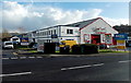
The Welsh Shop, Gwaelod-y-garth Road, Upper Boat
The Welsh Shop is on the right, City Plumbing is on the left.
Image: © Jaggery
Taken: 13 Feb 2014
0.13 miles
2
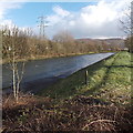
Riverbank track, Upper Boat
The track alongside the River Taff heads SE away from this road bridge. http://www.geograph.org.uk/photo/3847556
Image: © Jaggery
Taken: 13 Feb 2014
0.13 miles
3
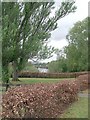
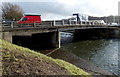
Treforest Industrial Estate
River Taff and the Gwaelod-y-Garth Road Bridge can be seen in the distance.
Image: © Kev Griffin
Taken: 25 Apr 2007
0.15 miles
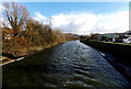
4
River Taff, Treforest Industrial Estate
Image: © Kev Griffin
Taken: 25 Apr 2007
0.15 miles
5
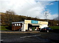
Greggs, Taffs Fall Road, Upper Boat
Located at the edge of the Treforest Industrial Estate, which is not
a geographically accurate name, as Treforest is about 3km to the NW.
Image: © Jaggery
Taken: 13 Feb 2014
0.15 miles
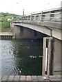
6
River Taff flows away from the A473 bridge in Upper Boat
Viewed from this bridge. http://www.geograph.org.uk/photo/3847636
Image: © Jaggery
Taken: 13 Feb 2014
0.17 miles
7
Gwaelod-y-Garth Road Bridge, Treforest Industrial Estate
Image: © Kev Griffin
Taken: 25 Apr 2007
0.17 miles
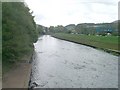
9
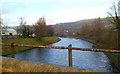
West side of the River Taff bridge, Upper Boat
The Taff is about 30 metres wide here. Viewed in mid-February during the very wet winter of 2013-2014. Though fast flowing today, the Taff in this area has not burst its banks. The water level is far below the bottom of the gauge (centre left).
Image: © Jaggery
Taken: 13 Feb 2014
0.18 miles
10
River Taff upstream from a former railway bridge, Treforest Industrial Estate
A view from the middle of this bridge. http://www.geograph.org.uk/photo/2753009
At the bottom of the view is a large-bore gas pipeline.
Image: © Jaggery
Taken: 6 Jan 2012
0.18 miles