IMAGES TAKEN NEAR TO
Cardiff Road, PONTYPRIDD, CF37 5RF
Introduction
This page details the photographs taken nearby to Cardiff Road, CF37 5RF by members of the Geograph project.
The Geograph project started in 2005 with the aim of publishing, organising and preserving representative images for every square kilometre of Great Britain, Ireland and the Isle of Man.

There are currently over 7.5m images from over14,400 individuals and you can help contribute to the project by visiting https://www.geograph.org.uk
Image Map
Images are licensed for reuse under creativecommons.org/licenses/by-sa/2.0
Notes
- Clicking on the map will re-center to the selected point.
- The higher the marker number, the further away the image location is from the centre of the postcode.
Image Listing (143 Images Found)
Images are licensed for reuse under creativecommons.org/licenses/by-sa/2.0
Image
Details
Distance
1

A473 Llantrisant turning from A470
At this point the southbound slip road to the A470 passes underneath
Image: © John Firth
Taken: 7 Sep 2012
0.04 miles
2

A470 in Glyntaff
The speed limit on this stretch of road has been imposed to reduce pollution
Image: © David Smith
Taken: 17 Sep 2022
0.05 miles
3
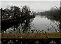
Downstream along the River Taff, Treforest
Viewed from Castle Bridge looking towards this https://www.geograph.org.uk/photo/2752675 weir.
Image: © Jaggery
Taken: 1 Mar 2019
0.08 miles
4
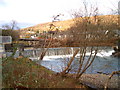
Treforest Weir and fish pass
Treforest weir was built to provide a water supply to the Tin plate works, the mill stream ran alongside the wall on the left side of the picture
Image: © nantcoly
Taken: 14 Dec 2005
0.08 miles
5
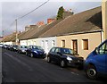
Southern end of Long Row, Treforest, Pontypridd
Looking north along a 200-metre long row of houses on the west bank of the River Taff.
Image: © Jaggery
Taken: 12 Jan 2012
0.09 miles
6
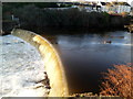
Treforest Weir
Looking west from first floor steps on a Cardiff Road (A4054) building.
The River Taff tumbles noisily down the weir, located 100 metres south of Castle Bridge. http://www.geograph.org.uk/photo/2752680
Image: © Jaggery
Taken: 9 Dec 2011
0.09 miles
7
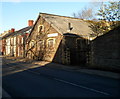
Bridge Precision Engineering Saxonby Ltd, Treforest
Premises at 27 Cardiff Road.
Image: © Jaggery
Taken: 9 Dec 2011
0.09 miles
8
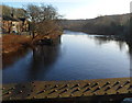
River Taff downstream from Castle Bridge, Treforest
Viewed from the middle of this bridge. http://www.geograph.org.uk/photo/2752680
About 100 metres ahead is Treforest Weir. http://www.geograph.org.uk/photo/2752675
Image: © Jaggery
Taken: 9 Dec 2011
0.09 miles
9
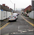
South along Meadow Street, Treforest
Viewed from Forest Road. The long row of single-storey houses on the left is named Long Row.
Image: © Jaggery
Taken: 1 Mar 2019
0.09 miles
10
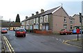
South side of John Street, Treforest, Pontypridd
Viewed past the corner of John Place looking towards Long Row. http://www.geograph.org.uk/photo/3427792
Image: © Jaggery
Taken: 12 Jan 2012
0.10 miles