IMAGES TAKEN NEAR TO
Church Road, PONTYPRIDD, CF37 4RN
Introduction
This page details the photographs taken nearby to Church Road, CF37 4RN by members of the Geograph project.
The Geograph project started in 2005 with the aim of publishing, organising and preserving representative images for every square kilometre of Great Britain, Ireland and the Isle of Man.

There are currently over 7.5m images from over14,400 individuals and you can help contribute to the project by visiting https://www.geograph.org.uk
Image Map
Images are licensed for reuse under creativecommons.org/licenses/by-sa/2.0
Notes
- Clicking on the map will re-center to the selected point.
- The higher the marker number, the further away the image location is from the centre of the postcode.
Image Listing (17 Images Found)
Images are licensed for reuse under creativecommons.org/licenses/by-sa/2.0
Image
Details
Distance
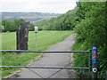
2
Bin Day on Coedpenmaen Rd
... 106 Coedpenmean Rd. The bin emptied, we're ready to go again.
Image: © Ian T
Taken: 24 May 1986
0.09 miles
3
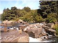
Waterfall on the Taff upstream of the disused railway bridge
View is of a waterfall on the river Taff north of the centre of Pontypridd and is used for paddling and picnicking in the summer.
Image: © nantcoly
Taken: 17 Jul 2005
0.15 miles
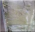
4
Ordnance Survey Cut Mark
This OS cut mark can be found on the old chapel on Bonvilston Road. It marks a point 73.945m above mean sea level.
Image: © Adrian Dust
Taken: 6 Jul 2018
0.16 miles
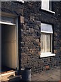
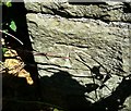
5
Ordnance Survey Cut Mark
This OS cut mark can be found on the N face of Capel Bethania. It marks a point 76.868m above mean sea level.
Image: © Adrian Dust
Taken: 6 Jul 2018
0.17 miles
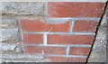
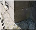
6
Ordnance Survey Cut Mark
This OS cut mark can be found on the NW buttress of the railway bridge. It marks a point 65.210m above mean sea level.
Image: © Adrian Dust
Taken: 6 Jul 2018
0.18 miles
7
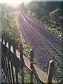
Railway Line
Abercynon to Pontypridd railway line at Craig yr Hesg.
Image: © Alan Hughes
Taken: 28 Nov 2016
0.18 miles
8
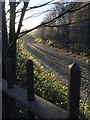
Railway Line
Abercynon to Pontypridd railway line.
Image: © Alan Hughes
Taken: 28 Nov 2016
0.19 miles

10
Ordnance Survey Cut Mark
This OS cut mark can be found on the SW angle of St Matthew's Church. It marks a point 73.030m above mean sea level.
Image: © Adrian Dust
Taken: 6 Jul 2018
0.21 miles