IMAGES TAKEN NEAR TO
Mynachdy Road, PONTYPRIDD, CF37 3PP
Introduction
This page details the photographs taken nearby to Mynachdy Road, CF37 3PP by members of the Geograph project.
The Geograph project started in 2005 with the aim of publishing, organising and preserving representative images for every square kilometre of Great Britain, Ireland and the Isle of Man.

There are currently over 7.5m images from over14,400 individuals and you can help contribute to the project by visiting https://www.geograph.org.uk
Image Map
Images are licensed for reuse under creativecommons.org/licenses/by-sa/2.0
Notes
- Clicking on the map will re-center to the selected point.
- The higher the marker number, the further away the image location is from the centre of the postcode.
Image Listing (31 Images Found)
Images are licensed for reuse under creativecommons.org/licenses/by-sa/2.0
Image
Details
Distance
1
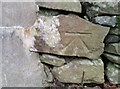
Ordnance Survey Cut Mark
This OS cut mark can be found on the wall of No3 Cefn-y-coed. It marks a point 206.560m above mean sea level.
Image: © Adrian Dust
Taken: 1 Mar 2021
0.01 miles
2
Yellow grit box alongside Mynachdy Road, Ynysybwl
On the steep ascent from Heol-y-Mynach to Mynachdy Farm. http://www.geograph.org.uk/photo/4433606
Image: © Jaggery
Taken: 16 Apr 2015
0.03 miles
3
Cyncoed, Ynysybwl
Housing on the west side of Heol-y-Mynach north of the Mynachdy Road junction.
Image: © Jaggery
Taken: 16 Apr 2015
0.04 miles
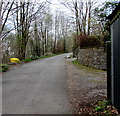
4
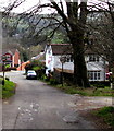
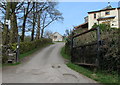
Mynachdy Road, Ynysybwl
Mynachdy Road climbs away from Heol-y-Mynach, towards Mynachdy Farm.
A few metres ahead, the 30 mph speed limit increases to the National Speed Limit.
Image: © Jaggery
Taken: 16 Apr 2015
0.05 miles
5
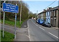
Towards the 30 zone, Mynachdy Road, Ynysybwl
The National Speed Limit drops to 30mph on the approach to the Heol-y-Mynach junction.
Image: © Jaggery
Taken: 16 Apr 2015
0.06 miles
6
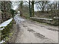
Road bridge
Bridge over a stream at Mynachdy.
Image: © Alan Hughes
Taken: 1 Feb 2021
0.07 miles
7
Unsuitable route for heavy goods vehicles, Ynysybwl
Alongside Heol-y-Mynach north of the Mynachdy Road junction. A small blue, red and white sticker
on a post supporting the sign shows that this route is part of National Cycle Network Route 47.
Image: © Jaggery
Taken: 16 Apr 2015
0.07 miles
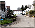
8

Bus at the turning circle in Ynysybwl
At the end of its journey on route 106 from Pontypridd bus station, the NAT (New Adventure Travel)
single-decker stops to pick up a passenger. It will shortly begin the return trip to Pontypridd.
The turning circle is at the junction of Mynachdy Road (on the left) and Heol-y-Mynach.
Image: © Jaggery
Taken: 16 Apr 2015
0.07 miles
9
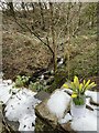
A friend?s tribute
A bunch of daffodils placed in a jar on the bridge at Mynachdy, in memory of a friend.
Image: © Alan Hughes
Taken: 1 Feb 2021
0.07 miles
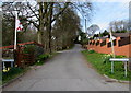
10
Entrance to Mynachdy Farm, Ynysybwl
From the top of Mynachdy Road. A notice on the low wall on the left shows Beware of the Dogs.
Image: © Jaggery
Taken: 16 Apr 2015
0.08 miles