1
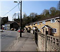
Windsor Court and Windsor Cottages, Ynysybwl
Housing on the west side of the B4273 Windsor Place. Windsor Court is on the right.
Image: © Jaggery
Taken: 16 Apr 2015
0.00 miles
2
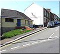
Windsor Cottages, Ynysybwl
Two semi-detached cottages on the west side of the B4273 Windsor Place.
Image: © Jaggery
Taken: 16 Apr 2015
0.01 miles
3
Ynysybwl Telephone Exchange
British Telecom site set back from the east side of Windsor Place.
Image: © Jaggery
Taken: 16 Apr 2015
0.02 miles
4
Station Yard surgery, Ynysybwl
Medical surgery set back 50 metres from Windsor Place in a former Great Western Railway building.
This is a branch surgery of Taff Vale Practice based in Rhydyfelin, Pontypridd.
There has not been a railway service in the village for many decades.
The last passenger train from Ynysybwl Halt to Pontypridd was in 1953.
Image: © Jaggery
Taken: 16 Apr 2015
0.04 miles
5
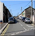
Penygraig Terrace houses, Ynysybwl
The car is in Paget Street. http://www.geograph.org.uk/photo/4433191
Image: © Jaggery
Taken: 16 Apr 2015
0.04 miles
6
Archer Street, Ynysybwl
The houses at the bottom are on Peygraig Terrace. The hill behind is Pen y Foel, with evidence of the coal tips from the local pit.
Image: © Steve Sheppard
Taken: 28 May 2007
0.05 miles
7
Ynysybwl Community Project hall
Located in the centre of the village, between Windsor Place on the right and Penygraig Terrace.
Image: © Jaggery
Taken: 16 Apr 2015
0.07 miles
8
Former Ynysybwl police station
Viewed in April 2015. The Police Station name board seen in a September 2009 Google Earth Street View
has gone from the single storey building at the eastern end of Paget Street.
Image: © Jaggery
Taken: 16 Apr 2015
0.07 miles
9
Paget Street, Ynysybwl
Looking westwards across Penygraig Terrace.
Image: © Jaggery
Taken: 16 Apr 2015
0.07 miles
10
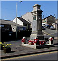
Ynysybwl Cenotaph War Memorial
Located in the centre of the village, between Windsor Place and Penygraig Terrace.
Cenotaph is derived from the Greek for empty tomb.
Image: © Jaggery
Taken: 16 Apr 2015
0.07 miles


