IMAGES TAKEN NEAR TO
Gelli Road, PONTYPRIDD, CF37 3HP
Introduction
This page details the photographs taken nearby to Gelli Road, CF37 3HP by members of the Geograph project.
The Geograph project started in 2005 with the aim of publishing, organising and preserving representative images for every square kilometre of Great Britain, Ireland and the Isle of Man.

There are currently over 7.5m images from over14,400 individuals and you can help contribute to the project by visiting https://www.geograph.org.uk
Image Map
Images are licensed for reuse under creativecommons.org/licenses/by-sa/2.0
Notes
- Clicking on the map will re-center to the selected point.
- The higher the marker number, the further away the image location is from the centre of the postcode.
Image Listing (68 Images Found)
Images are licensed for reuse under creativecommons.org/licenses/by-sa/2.0
Image
Details
Distance
1
Glyn Mynach Street, Ynysybwl
Located between the B4273 Robert Street to the west and a stream, Nant Clydach, to the east.
Image: © Jaggery
Taken: 16 Apr 2015
0.03 miles
2
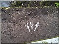
Ordnance Survey Rivet
This OS rivet can be found on the footbridge. It marks a point 124.800m above mean sea level.
Image: © Adrian Dust
Taken: 1 Mar 2021
0.03 miles
3
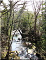
Nant Clydach, Ynysybwl
Viewed from this http://www.geograph.org.uk/photo/4433320 footbridge. The stream is a tributary of the River Taff.
Image: © Jaggery
Taken: 16 Apr 2015
0.04 miles
4
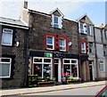
Nick's Allsorts, Ynysybwl
Robert Street shop selling flowers, household items, toiletries and all sorts of other items.
Image: © Jaggery
Taken: 16 Apr 2015
0.05 miles
5
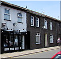
T.C.Unisex hair salon in Ynysybwl
Viewed across Robert Street.
Image: © Jaggery
Taken: 16 Apr 2015
0.05 miles
6
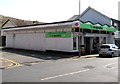
The Co-operative Food store and post office, Ynysybwl
On the corner of Robert Street and Glyn Mynach Street. In April 2015, there is a post office counter inside this store. The vacant former post office http://www.geograph.org.uk/photo/4431780 is in Windsor Place.
Image: © Jaggery
Taken: 16 Apr 2015
0.05 miles
7
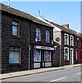
Robert News, Ynysybwl
Robert Street newsagent and convenience store.
Image: © Jaggery
Taken: 16 Apr 2015
0.06 miles
8
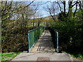
Nant Clydach footbridge, Ynysybwl
From Gelli Road on this side, the bridge spans a stream, Nant Clydach.
On the far side, steps and a zigzag ramp lead up to a footpath and cycleway,
part of National Cycle Network Route 47.
Image: © Jaggery
Taken: 16 Apr 2015
0.06 miles
9
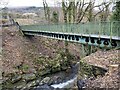
Footbridge over river
Footbridge over Nant Clydach at Ynysybwl.
Image: © Alan Hughes
Taken: 1 Feb 2021
0.06 miles
10
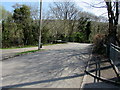
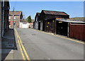
Gelli Road, Ynysybwl
Viewed from the corner of Robert Street. Gelli Road is a dead-end road on the west bank of a stream,
Nant Clydach. The southern end of a footbridge http://www.geograph.org.uk/photo/4433320 over the stream is in the background.
Image: © Jaggery
Taken: 16 Apr 2015
0.06 miles