IMAGES TAKEN NEAR TO
Robert Street, PONTYPRIDD, CF37 3EP

Introduction

This page details the photographs taken nearby to Robert Street, CF37 3EP by members of the Geograph project.

The Geograph project started in 2005 with the aim of publishing, organising and preserving representative images for every square kilometre of Great Britain, Ireland and the Isle of Man.

There are currently over 7.5m images from over14,400 individuals and you can help contribute to the project by visiting https://www.geograph.org.uk

Image Map


Images are licensed for reuse under creativecommons.org/licenses/by-sa/2.0
Notes
  • Clicking on the map will re-center to the selected point.
  • The higher the marker number, the further away the image location is from the centre of the postcode.

Image Listing (55 Images Found)

Images are licensed for reuse under creativecommons.org/licenses/by-sa/2.0
  • ...
Image
Details
Distance
1
Are you with us?
An old, closed Woolwich branch, Ynysybwl
Image: © Nick Mutton 01329 000000 Taken: 23 Sep 2007
0.01 miles
2
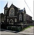
Glyn Street Presbyterian Church, Ynysybwl
Located near the corner of the B4273 Robert Street.
Image: © Jaggery Taken: 16 Apr 2015
0.01 miles
3
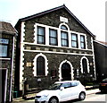
Ynysybwl Warehouse
The nameboard shows YNYSYBWL WAREHOUSE OPEN TO THE PUBLIC EVERY DAY 9 AM-5.30 PM, but the Robert Street building is boarded up in April 2015. The inscription in Welsh on a stone tablet shows that this was originally Ebenezer Wesleyan chapel (1892).
Image: © Jaggery Taken: 16 Apr 2015
0.02 miles
4
Ynysybwl High Street
Image: © Nick Mutton 01329 000000 Taken: 23 Sep 2007
0.03 miles
5
Ordnance Survey Cut Mark
This OS cut mark can be found on No89 Robert Street. It marks a point 130.755m above mean sea level.
Image: © Adrian Dust Taken: 1 Mar 2021
0.04 miles
6
Zion Baptist Church, Ynysybwl
Viewed across Robert Street. The inscription on the stone tablet above the windows shows that this is the 1905 rebuilt of the 1830 original.
Image: © Jaggery Taken: 16 Apr 2015
0.04 miles
7
Aelwyd, Ynysybwl
The former chapel on the east side of Robert Street has been converted to residential use.
Image: © Jaggery Taken: 16 Apr 2015
0.06 miles
8
Cribyn Ddu Street electricity substation, Ynysybwl
The Western Power Distribution electricity substation identifier shows Cribyn Ddu Street whereas a nearby street name sign has Cribbinddu Street.
Image: © Jaggery Taken: 16 Apr 2015
0.07 miles
9
Robert Street
Image: © Colin Pyle Taken: 31 Aug 2010
0.07 miles
10
Up Cribbinddu Street, Ynysybwl
Cribbinddu Street ascends from Robert Street towards Thompson Street. The 30mph speed limit reduces to 20mph on the approach to a school. Some references show Cribyn-Ddu Street. I've used the spelling shown on the street name sign.
Image: © Jaggery Taken: 16 Apr 2015
0.09 miles
  • ...