IMAGES TAKEN NEAR TO
Grove Terrace, PONTYPRIDD, CF37 3EH
Introduction
This page details the photographs taken nearby to Grove Terrace, CF37 3EH by members of the Geograph project.
The Geograph project started in 2005 with the aim of publishing, organising and preserving representative images for every square kilometre of Great Britain, Ireland and the Isle of Man.

There are currently over 7.5m images from over14,400 individuals and you can help contribute to the project by visiting https://www.geograph.org.uk
Image Map
Images are licensed for reuse under creativecommons.org/licenses/by-sa/2.0
Notes
- Clicking on the map will re-center to the selected point.
- The higher the marker number, the further away the image location is from the centre of the postcode.
Image Listing (66 Images Found)
Images are licensed for reuse under creativecommons.org/licenses/by-sa/2.0
Image
Details
Distance
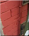
1
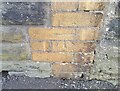
Ordnance Survey Cut Mark
This OS cut mark can be found on the wall of the school on Grove Terrace. It marks a point 142.499m above mean sea level.
Image: © Adrian Dust
Taken: 1 Mar 2021
0.01 miles
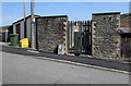
2
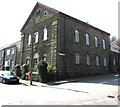
Jerusalem Chapel, Ynysybwl
The derelict building on the corner of Thompson Street and Grove Terrace
was Jerusalem, one of the largest chapels in the village, from 1888-1976.
Image: © Jaggery
Taken: 16 Apr 2015
0.01 miles
3
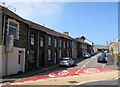
Up Cribbinddu Street, Ynysybwl
Cribbinddu Street ascends from Robert Street towards Thompson Street. The 30mph speed limit reduces to 20mph on the approach to a school. Some references show Cribyn-Ddu Street. I've used the spelling shown on the street name sign.
Image: © Jaggery
Taken: 16 Apr 2015
0.03 miles
4
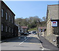
Grove Terrace, Ynysybwl
From Thompson Street.
The derelict former Jerusalem chapel http://www.geograph.org.uk/photo/4432691 is on the left.
Trerobart Primary School http://www.geograph.org.uk/photo/4432682 is on the right.
Image: © Jaggery
Taken: 16 Apr 2015
0.04 miles
5
Cribyn Ddu Street electricity substation, Ynysybwl
The Western Power Distribution electricity substation identifier shows Cribyn Ddu Street whereas a nearby street name sign has Cribbinddu Street.
Image: © Jaggery
Taken: 16 Apr 2015
0.04 miles
6
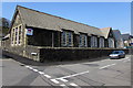
Trerobart Primary School, Ynysybwl
On the west side of Thompson Street and the south side of Grove Terrace.
Image: © Jaggery
Taken: 16 Apr 2015
0.05 miles
7
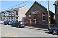
Crossroads Christian Community Centre, Ynysybwl
In Thompson Street, opposite Trerobart Primary School. Originally a Wesleyan English Methodist church.
Image: © Jaggery
Taken: 16 Apr 2015
0.05 miles
8
Ordnance Survey Cut Mark
This OS cut mark can be found on No89 Robert Street. It marks a point 130.755m above mean sea level.
Image: © Adrian Dust
Taken: 1 Mar 2021
0.07 miles
9
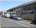
Was the Woolwich in Ynysybwl
A long derelict former building society branch in Robert Street.
The Woolwich was one of the largest UK building societies, well known from its TV advertising slogan
"I'm with the Woolwich". The Woolwich Equitable Building Society demutualised in 1997, becoming a bank named Woolwich PLC. In August 2000, Barclays took over Woolwich PLC. The Woolwich brand name was retained until 2006 when Barclays announced that the Woolwich was to become the Barclays UK mortgage brand, and that Woolwich branches would be either closed or rebranded as Barclays.
Image: © Jaggery
Taken: 16 Apr 2015
0.07 miles
10
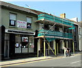
Diamond Beauty and Flying Solo hair design in Ynysybwl
Beauty salon and hair salon under one roof in Robert Street.
The name on the building under scaffolding next door is Ynysybwl Library. In April 2015,
the Rhondda Cynon Taf Council website lists 13 libraries. Ynysybwl Library is not on the list.
Image: © Jaggery
Taken: 16 Apr 2015
0.07 miles