IMAGES TAKEN NEAR TO
Bridge Street, PONTYPRIDD, CF37 2NN
Introduction
This page details the photographs taken nearby to Bridge Street, CF37 2NN by members of the Geograph project.
The Geograph project started in 2005 with the aim of publishing, organising and preserving representative images for every square kilometre of Great Britain, Ireland and the Isle of Man.

There are currently over 7.5m images from over14,400 individuals and you can help contribute to the project by visiting https://www.geograph.org.uk
Image Map
Images are licensed for reuse under creativecommons.org/licenses/by-sa/2.0
Notes
- Clicking on the map will re-center to the selected point.
- The higher the marker number, the further away the image location is from the centre of the postcode.
Image Listing (78 Images Found)
Images are licensed for reuse under creativecommons.org/licenses/by-sa/2.0
Image
Details
Distance
1
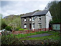
Thomas's Place, Trehafod
These two remaining cottages in Thomas's Place at the bottom of Cwm George have suffered from subsidence as a result of coal mining.
Image: © David Pike
Taken: Unknown
0.02 miles
2
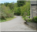
Bridge Street, Trehafod
Bridge Street heads north past the edge of one of the two remaining houses http://www.geograph.org.uk/photo/2428581 on the street.
A rather faded Bridge Street name plate is on the building.
Image: © Jaggery
Taken: 6 May 2011
0.04 miles
3
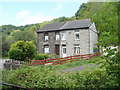
Bridge Street houses, Trehafod
Though numbered 7 and 8, these are now the only houses remaining on Bridge Street, located near its southern edge, close to Trehafod railway station http://www.geograph.org.uk/photo/2428498 and the River Rhondda.
Image: © Jaggery
Taken: 6 May 2011
0.04 miles
4
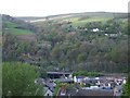
Two bridges over the Rhondda
New and old bridge over the river Rhondda at Trehafod, with the hillsides in the background
Image: © Mike Kohnstamm
Taken: 26 Apr 2009
0.06 miles
5
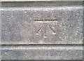
Ordnance Survey Cut Mark
This OS cut mark can be found on the SE parapet SW side of the Lower Eirw Bridge. It marks a point 76.496m above mean sea level.
Image: © Adrian Dust
Taken: 24 Jun 2017
0.07 miles
6
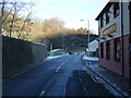
Trehafod Road and bridge over River Rhondda
Image: © Colin Pyle
Taken: 4 Jan 2010
0.07 miles
7
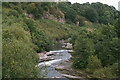
Trehafod - River Rhondda
View east from footbridge.
Image: © Dave Bevis
Taken: 1 Sep 1999
0.09 miles
9
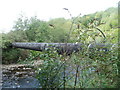
Pipe across the River Rhondda, Trehafod
Viewed from Bridge Street. A few metres north of two bridges, one road and one railway, a large-bore pipe crosses the River Rhondda.
Image: © Jaggery
Taken: 6 May 2011
0.09 miles
10
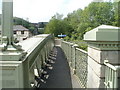
Separate footpath, Lower Eirw Bridge, Trehafod
Pedestrians cross over the River Rhondda using a footpath separated from the roadway on the Grade II listed bridge. http://www.geograph.org.uk/photo/2428814
Image: © Jaggery
Taken: 6 May 2011
0.09 miles