1
Ordnance Survey Cut Mark
This OS cut mark can be found on the NE face of the School. It marks a point 73.390m above mean sea level.
Image: © Adrian Dust
Taken: 24 Jun 2017
0.03 miles
2
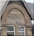
Inscription on Hafod Primary School, Trehafod
The inscription on the school http://www.geograph.org.uk/photo/2397518 shows
LLANWONNO
SCHOOL BOARD
HAFOD SCHOOLS
I was surprised that Llanwonno (also spelt Llanwynno) once had a school board, as it is a tiny hamlet
Image consisting of one church and one pub, (and no houses!) in St Gwynno Forest. The explanation is that the ancient parish of Llanwonno was centred at the church, but covered a wide area of the Rhondda, including Porth, Abercynon and parts of Mountain Ash and Pontypridd.
Image: © Jaggery
Taken: 6 May 2011
0.04 miles
3
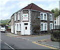
Hafod Primary School, Trehafod
Located on Wayne Street. The school's playground borders the north bank of the River Rhondda.
Image: © Jaggery
Taken: 6 May 2011
0.04 miles
4
Flats in former Bethesda Chapel, Trehafod
The former chapel, built in the 1880s on the corner of Trehafod Road and Bethesda Street, has been converted to flats.
Image: © Jaggery
Taken: 6 May 2011
0.04 miles
5
Ty Gwyn guest house, Trehafod
Guest house offering bed & breakfast accommodation, located on the corner of Trehafod Road and Cross Street. The guest house is open all year.
Image: © Jaggery
Taken: 6 May 2011
0.04 miles
6
Trehafod and the Rhondda River
Image: © Gareth James
Taken: 4 Apr 2015
0.04 miles
7
Girder Avenue
An avenue of arched steel girders makes an interesting and unusual approach to Trehafod railway station.
Image: © Alan Hughes
Taken: 9 Mar 2017
0.05 miles
8
Platform for southbound trains, Trehafod railway station
This platform, on the north side of the station, http://www.geograph.org.uk/photo/2428498 is for Pontypridd, Cardiff Central and stations in between.
Image: © Jaggery
Taken: 6 May 2011
0.05 miles
9
Passenger shelters, Trehafod railway station
There is one basic shelter on each of the two platforms at the unmanned station on the Rhondda Line route operated by Arriva Trains Wales.
Image: © Jaggery
Taken: 6 May 2011
0.05 miles
10
Trehafod railway station viewed from the SE
The station, built on a curve, is on the Rhondda Lines route operated by Arriva Trains Wales. The next station in this direction is Porth.
Image: © Jaggery
Taken: 6 May 2011
0.05 miles


